
Walking and biking advocates hope to convince MDOT on vision for Ann Arbor's North Main corridor
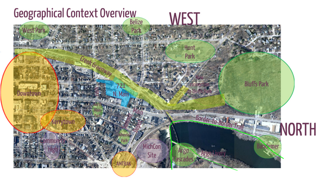
Ann Arbor's North Main-Huron River corridor in the context of its surroundings. A citizen-led task force has been studying ways to improve connections and access to the river and will make recommendations to the City Council by July 31.
Courtesy image
But while city officials and citizens leading a 14-member task force may have ambitious ideas for achieving those goals with pedestrians, bicyclists and motorists in mind, it's the Michigan Department of Transportation that gets final say on much of what happens on North Main Street.
"It's good to be the king," quipped David Santacroce, chairman of the city's North Main-Huron River Vision Task Force, referring to MDOT at a recent community meeting.
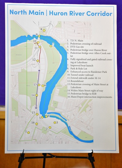
This map on display at a recent community meeting gives an overview of the 16 different ideas being considered by the task force for the North Main-Huron River corridor. Download the full presentation from the meeting.
Ryan J. Stanton | AnnArbor.com
City officials are hopeful MDOT will consider some of the community's ideas for improved walking and biking amenities in conjunction with that project.
Some of the ideas coming out of the task force that can't happen without MDOT approval include reducing traffic speeds along North Main, adding new crosswalks, putting in a roundabout for traffic coming off the highway at M-14, and maintaining a signalized railroad crossing at Lake Shore Drive into Bandemer Park where the current at-grade crossing is at risk of closing.
The task force also has expressed interest in widening the Main Street right-of-way and improving and extending the sidewalk on the east side of North Main from Depot Street to and under M-14 to enhance pedestrian and bike access to West Huron River Drive.
Santacroce said there is a continuing dialogue between the city and MDOT on the many issues along the corridor and he doesn't sense that the relationship is hostile — just two different parties with different issues and different constituencies, and limited pots of money.
Mark Sweeney, MDOT's regional manager in Brighton, declined to comment Friday on the task force's ideas that are still in draft form.
"MDOT has always been on record as supporting complete streets initiatives," he said. "However, we cannot comment on recommendations that have not been officially presented to us by the city."
The task force, which was formed by the Ann Arbor City Council last May, is expected to submit its final report with recommendations to the council by July 31.
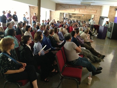
Nearly 100 members of the community packed into the Ann Arbor Community Center for a meeting this past Wednesday to hear the latest plans from the North Main-Huron River task force and give feedback.
Ryan J. Stanton | AnnArbor.com
Nearly 100 people packed the Community Center this past Wednesday night to hear the latest plans from the task force and give feedback. Opinions were mixed about the various ideas on the table — some are more popular than others — but most seemed to agree there's at least room for improvement along the corridor.
"For the most part, I think people were appreciative of the work the task force has done and supportive of most of the preliminary ideas we put out there," Santacroce said. "For some ideas, there were mixed reactions, and probably no one in the room agreed with every one, but the point of the meeting was to make sure the task force had identified all the issues."
Santacroce hopes more people will add their voices online at A2 Open City Hall by the Tuesday deadline for submitting comments.
Erica Briggs of the Washtenaw Bicycling and Walking Coalition said her group is launching an advocacy campaign to convince MDOT to seriously consider ideas for North Main.
"There are some things that we're really going to need to get active on as a community, and the city can only do certain types of advocacy work," she said.
One of the issues the WBWC will be focusing on, Briggs said, is the threat that MDOT could close the only legal railroad crossing off North Main into Bandemer Park at Lake Shore Drive.
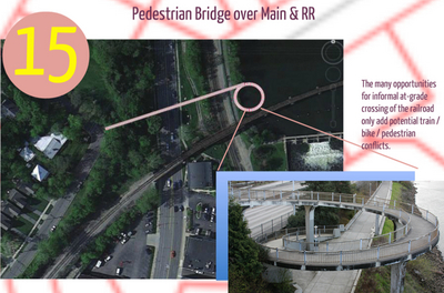
Rough plans released this past week show a pedestrian bridge proposed over North Main and the railroad tracks that act as a barrier to the river. The bridge would start at Wildt Street and go over the road and tracks before spiraling down at the Border-to-Border Trail next to Argo Pond.
Courtesy image
"We'll be stepping up in the next couple of years and really trying to make sure that people are telling MDOT they do not want to have Lake Shore Drive closed," Briggs said, "and telling MDOT that we need to have the street construction done sooner rather than later."
Briggs said she's excited about ideas like putting in new crosswalks, including a user-activated signal to cross North Main from Bluffs Park to Bandemer Park at Lake Shore Drive. She said it's also important to be talking about slowing traffic coming off the highway onto North Main.
Task force member Darren McKinnon, a representative of the Water Hill neighborhood in the area, said widening the road right-of-way and installing sidewalks on the west side of North Main need to happen before the city can make a case to MDOT for pedestrian crossings north of Depot.
"What we're being told is, if you don't put in a sidewalk, there's nothing to cross to, and so you're never going to get a crosswalk," he said.
But the task force does believe it's possible in the short term to establish new pedestrian crosswalks across Depot at Fourth Avenue and across Main at Depot.
Rough plans released this past week also show a pedestrian bridge proposed over North Main and the railroad tracks that act as a barrier to the river. The bridge would start at Wildt Street and go over the road and tracks before spiraling down at the Border-to-Border Trail next to Argo Pond.
The task force is continuing to look at options for tunneling under the railroad tracks just north of Depot and Fourth Avenue to provide access to a future park at the MichCon site, too. And from there, the tentative plan is to have two pedestrian bridges crossing over the river to Argo Park and the Border-to-Border Trail — one bridge on each side of Argo Dam.
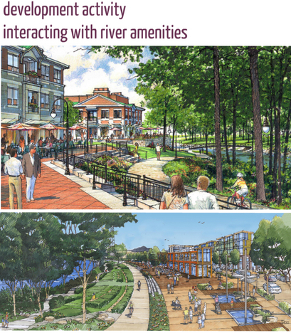
Two generic images included in a presentation given Wednesday night show what development can look like next to public riverfront amenities, though they're not intended to depict the MichCon site specifically
Courtesy image
Two generic images included in a presentation given Wednesday night show what development can look like next to public riverfront amenities, though they're not intended to depict the MichCon site specifically.
"They're meant to evoke a vision," said task force member Julie Grand, chairwoman of the city's Park Advisory Commission. "They were just an example of what a private-public riverfront can look like, not necessarily our riverfront — just how private development and public parks can co-exist."
DTE Energy is still sifting through proposals from developers interested in the site. That could include restaurant, retail, residential, commercial office space and medical office uses.
In addition to the MichCon site, the task force will be recommending public open space uses for the former city maintenance yard at 721 N. Main as part of the Allen Creek Greenway.
Other ideas being kicked around include an improved boat launch at Bandemer Park, an improved two-lane bridge to make Bandemer Park more accessible, widening the Border-to-Border Trail at some points, a park-and-ride lot at M-14 and Barton Drive to help take traffic off North Main, and a tunnel under the railroad tracks north of M-14 to link the Barton Nature Area with Bandemer Park.
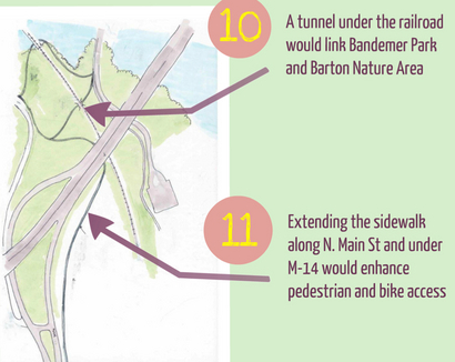
No. 10. on the task force's list of ideas is a tunnel under the railroad tracks north of M-14 to link the Barton Nature Area with Bandemer Park. That's an area where many people already cross the tracks illegally. No. 11 is an extension of the sidewalk along the east side of North Main under M-14 to enhance pedestrian and bike access to West Huron River Drive.
Courtesy image
"You may have seen there's some rail sitting out there now waiting to be installed," he said. "Most of the track work will be done this year."
He said the stretch from Kalamazoo to Battle Creek is expected to be up to 110 mph by Christmas, and the stretch from Battle Creek to Dearborn should be done by the end of next year.
"They obviously can't go 110 mph through some of these curves along the Huron River. However, they probably will be going faster," he said.
As for the at-grade crossing at Lake Shore Drive, he said it's not a simple matter, and it's worth noting the newer equipment will be quieter, "so you may not hear the train."
He said the crossing was always pretty safe until earlier this year when a train hit a car stopped on the tracks.
"One of the problems with Lake Shore Drive is that's not just out in the open country. That's in the middle of a railroad yard, believe it or not," he said. "There are multiple tracks, and there may very well be additional tracks put in there, so you could have the crossing blocked when people are switching or doing something, depending what happens, for example, with commuter trains here."
Ryan J. Stanton covers government and politics for AnnArbor.com. Reach him at ryanstanton@annarbor.com or 734-623-2529. You also can follow him on Twitter or subscribe to AnnArbor.com's email newsletters.
Comments
a2roots
Mon, May 27, 2013 : 2:53 p.m.
The wbwc will try to get their way. Unlike the passage of the non motorized transportation plan which went through under the radar this will not. Quite apparent the proponents of wbwc were hoping that common sense citizen input would be void and only their agenda put forth. Ann Arbor citizens need to jump up and stop the insanity with how roads are being transformed to accommodate bicycles rather cars. Build it and they will come has proven not to work. Packard, Stadium, South Main are a few examples of realignments that have minimal bicycle ridership.
Tom Joad
Sun, May 26, 2013 : 8:02 p.m.
The North Main entrance to M-14 is single lane. That's the bottleneck. You have to be in the RIGHT lane to merge onto M-14. What you have now are cars racing in the left lane to merge into the right lane which is dangerous for all drivers, particularly those who have already lined up in the correct (right lane). A single lane on N. Main is not going to impede traffic flow; in fact it will make it eminently safer. As it is now, traffic in both directions traveling at well over the 45 mph speed limit is not safe because of the condition of the road and the narrow lanes. Single lanes in both directions with a median in the center would be traffic calming as well as a showcase entrance to downtown Ann Arbor. It becomes single lane travel once you hit Miller anyway going south. Bike lanes would be a welcome addition along that stretch as well as it will encourage ridership and have its own traffic-calming effect highlighting the fact to resident and visitor alike that Ann Arbor is a leader in alternative transportation. While there is a current bike path, it's not easily accessible and relegating riders to that path is counter to the goal of providing efficient and safe bicycle travel to areas areas that are now for all practical purposes off-limits to cyclists.
liebezeit
Wed, Jun 5, 2013 : 12:05 p.m.
"The notion of a single lane on North Main fails to take into account vehicles turning left onto Huron River Drive, that will cause traffic backups while waiting for a break in traffic exiting the M-14 and heading into town." But there would be a center turn lane. That takes care of the left from northbound Main to Huron River Drive, and the backed-up left from southbound Main to Depot. As Tom, says, it's one lane at both ends (M-14 and Miller), so why not in the middle? This road diet makes a lot of sense. "A bike lane on the northbound Main Street would require riders to cross against inbound traffic exiting M-14 to reach Huron River Drive." The concept presented that simply continues the Main Street sidewalk under M-14 to connect to Barton Nature Area would be relatively affordable (there's already room under the M-14 bridge next to the tracks) and would be a minor detour for bicycle traffic headed westbound on Huron River Drive. The tunnel, while presumably more expensive, also makes a lot of sense as we should aim, as much as possible, to make complete trails for both sides of the river. We've got parks all along it but you can't legally get from one park to the other.
Merlin
Mon, May 27, 2013 : 2:35 p.m.
"A single lane on N. Main is not going to impede traffic flow" The notion of a single lane on North Main fails to take into account vehicles turning left onto Huron River Drive, that will cause traffic backups while waiting for a break in traffic exiting the M-14 and heading into town. "Bike lanes would be a welcome addition along that stretch as well as it will encourage ridership...." A bike lane on the northbound Main Street would require riders to cross against inbound traffic exiting M-14 to reach Huron River Drive. As a cyclist, I would much prefer to ride on a path near the river than adjacent to traffic entering and exiting the freeway. Most cyclists in this area are not commuting, they are likely out for a pleasure ride.
Michael
Sun, May 26, 2013 : 9:22 p.m.
Very well said. Many people say "I don't see any bikes or pedestrians, so why make room for them?" without even thinking about what they're saying. The very reason why there are not bikes or pedestrians along this stretch is precisely because of the traffic speed and amount of traffic present. The measures proposed to increase safety along the corridor by reducing lanes, adding bike lanes, improved pedestrian mobility, will make the corridor not only more vibrant and a great entrance into A2, but it also encourages more users to ultimately use the corridor.
annarboral
Sun, May 26, 2013 : 4:35 p.m.
Since there is no mention of costs then all this must be free, yeah right. There is absolutely "no free lunch". Whenever we discuss any proposal one of the first things we need to identify is how much it might cost and how we would pay for it. I'm neither for or against this rather large proposal but I insist on full disclosure of the costs and how we would pay for them "in advance" of any decision making.
hmsp
Sun, May 26, 2013 : 2:24 p.m.
So, what is the City to do about the "Argo Cascades" snafu? The big problem is the very nature of the Canoe Livery system –– here we have an entire industry based on renting boats to people who don't know how to paddle! Stupid? Yes! It's like renting your fleet of cars out to non-drivers and having them practice parking at Whole Foods Washtenaw, then acting shocked that your cars get scratched and dented! If the City is going to dabble in the livery business, it has two choices, as I see it: * Accept the basic premise of this industry, and get over it, or, * Provide paddling instruction, with real instructors, not just kids who ALMOST know how to paddle. Once paddlers achieve a certain skill level, the City could issue a "Paddling License" that allowed those paddlers to take City canoes through the "Cascades." This would be a much more realistic fix than building and staffing a completely separate livery set-up just a few feet from the existing one. And I'm sure that improving the paddling skills of its customers would help with the City's liability as well.
Stephen Lange Ranzini
Sun, May 26, 2013 : 6:59 p.m.
@hmsp: I really like your idea of the city providing paddling instruction and issuing Paddling Licenses to be able to go down the Argo Cascades in city owned canoes! I'd certainly get my license. It could a actually be priced to make a small profit and fund other needed things in the parks or canoe livery service.
hmsp
Sun, May 26, 2013 : 2:16 p.m.
@ Mr. Ranzini, re: "... a mistake our city leaders made when approving plans for the rapids." You and I have both pointed out this problem before in our aa.com comments, and we both agree that building another livery is NOT the answer. Perhaps a set of stairs might help, but that is what we had before, and that is the very thing that the "Cascades" were designed to replace! These "Cascades" were designed to be a minimal-flow, novice-friendly bypass around Argo Dam. Part of the problem is that the flow is TOO minimal, though, making the drops between pools sharper, and more disconcerting than necessary for inexperienced paddlers. Twice the flow would wash the drops out a bit. Being artificial, and of such minimal flow, the "Cascades" are hard to rate, but they are not "rapids," and they are not "whitewater." As you note, "the company chosen was inexperienced at building such features," yet decided that it was qualified to rate them as "Class II Whitewater," despite their admitted lack of knowledge of these things. Do geologists rate the climbing difficulty of a given rock face? Take it one step further, and you have guys from Dow Chemical rating the difficulty of that plastic wall at the local climbing gym! No, CLIMBERS rate climbing difficulty, and PADDLERS rate paddling difficulty. The "Cascades," while a bit weird, are off the bottom of the International Scale of River Difficulty, or rate a weak Class I at best.
ordmad
Sun, May 26, 2013 : 12:57 p.m.
Dear Mr. Ranzini: There is no "report" and there are no proposals yet. Had you read this article carefully or the preface to the presentation you viewed, you would have learned that this meeting was about getting community input on the taskforce's identification of the various issues in the area and very preliminary ideas about potential solutions. So rather than sit back and arm chair quarterback in a local "newspaper," how about getting involved? I don't see comments from you on this topic in A2 City Hall where they are needed. How about getting involved there or showing up to the June 12th meeting? I've been to many of the taskforce's meetings and was at this community meeting and I haven't seen you at any. These are the ways that people who are truly interested in helping shape this citizens' groups recommendations to City Council get involved.
Bcar
Tue, May 28, 2013 : 11:15 a.m.
As an FYI, these meetings were the MOST INEFFICIENT meetings I've ever been to... 45 min to discuss who to send the draft sections to....no, I'm not kidding...
ordmad
Sun, May 26, 2013 : 2:27 p.m.
@ Mr. Ranzini: It's not a draft of anything and we were told at the meeting that the vast majority of these images were created by the citizens on the taskforce. What I'm criticizing is what appears to be your sense that criticizing the work of others here seems to be your level of civic engagement on this and a multitude of other issues which you opine on.
DJBudSonic
Sun, May 26, 2013 : 2:10 p.m.
This document is clearly on the path to becoming a planning advisory document, which will then become part of the master plan; Bonnie Bona of the planning commission said as much when asked to describe the process at the meeting. It also mirrors or replicates much of the information in the Lowertown plan chapter that was considered for acceptance into the master plan the night before this meeting at the planning commission meeting. This task force is seeking input, yes, but when that input is integrated (or not) into this document, it will be presented to council for acceptance, ending the task forces job. If it is accepted as an advisory report it very well could become part of the master plan. Of course, many other advisory documents are overlooked when zoning and planning are set, for instance the Calthorpe Report is cherry-picked for "planning advice", or ignored, as best suits the planning flavor of the month.
Stephen Lange Ranzini
Sun, May 26, 2013 : 1:49 p.m.
@Ordmad: The presentation is something like 83 pages long and with its fancy graphics is clearly a draft version of the final report and recommendations. I plan to submit my own comments to A2 City Hall in the next day or two taking into account and modifying them if any good comments are made to my posts above. Rather than criticizing people who have schedule conflicts and family obligations that prevent them from attending meetings, why not welcome good comments that improve the process, or tell me why my ideas are flawed and not deserving to be considered?
Brad
Sun, May 26, 2013 : 1:27 p.m.
"Those are the ways" ... according to you. And how would anybody know if you were there or not?
sandy schopbach
Sun, May 26, 2013 : 12:53 p.m.
Accessing Huron River Drive from North Main is very dangerous. I don't know how many accidents have occurred there, but there have probably been a lot of near misses! Obviously you can't have a stoplight at the foot of a blind exit from M-14. But maybe there's something else that can be done. An underpass or overpass.
golfer
Sun, May 26, 2013 : 12:14 p.m.
might want to consider using the bike lanes on stadium blvd. they already messed it up for cars. hardly see bikes use the lanes. might be trying to much to soon for bikes. let them prove they need the lanes.
motorcycleminer
Sun, May 26, 2013 : 4:08 p.m.
With his honor in this for his and friends personal bike and choo-choo interests ..it will become just another huge waste of our tax $$$ like the south and north side sidewalk /bike paths on eastern washtenaw ave....untill he and his minions go bye-bye it will be cold day west of Pinckney before any reality runs our town..sadly look forward to many more " crash - go- rounds " and traffic squeezes to deal with for those of us who have to live under the bubble...
Jim Osborn
Sun, May 26, 2013 : 12:03 p.m.
Having bicycle lanes along North Main is silly, If I ride my bike, I much rather have a nice trail via Bandemer Park as it is both safer and more attractive. There is little reason to go on a bike from down town to North Main and M-14 except to get to Huron RIver Drive for pleasure, so why not use Bandemer Park? I do not want to ride a bike with cars racing by next to me, nor do I want to see this main road chocked down to one lane in each direction.when driving my car. or be forced to go 30 MPH. The present speed limit is good. We need the railroad crossing. It is very easy to make it safer, with advance warning lights and bells. Gates are overkill. Make tha warning more than just 10 to 20 seconds, though. Teh area where the actual tracks cross the crossing need to be filled in as much as possible so as t minimize trip hazzards and even allow wheelchairs. I've seen this done in California.
KJMClark
Mon, May 27, 2013 : 11:46 a.m.
That's ironic. Jim wants ordmad to speak for himself, and then Jim turns around and claims to represent lots of people too. Sorry, but ordmad's right. There's a large community of road cyclists who want to get to Huron River Drive and Main's the only legal way to get there. I'm not speaking for them, just my family, and we'd prefer to have access on the roads. Though personally I don't mind the current situation - when I'm biking on North Main, I end up using the whole right lane, then I signal for a left, move to the left lane and use the whole left lane, then turn onto HRD. And I'm an experienced road cyclist, so when I say "using the lane", that ends up being for several hundred feet, since that's how cyclists are supposed to do lane changes on busy roads.
Jim Osborn
Mon, May 27, 2013 : 11:10 a.m.
"biking community?" I doubt that you speak for all. I ride a bike as do many of my friends with their children, and they prefer staying off busy streets so their little Johnny is not read about in Ann Arbor dot Com as a tragedy. We ride bikes and are part of a "community" A crossing should be built further north near M-14, too. a simple one with lights and bells. Make it legal. Problem solved, change the law and conditions to suit the need.
ordmad
Sun, May 26, 2013 : 2:23 p.m.
You can't get to Bandemer from Main Street unless you cross the tracks illegally or at the potentially to be removed crossing at the boathouse. Most members of the biking community are in fact interested in riding up Main to Huron River.
Stephen Lange Ranzini
Sun, May 26, 2013 : 11:26 a.m.
The Report on page 57 proposes adding "Livery Operations" at the DTE site less than 1/3rd mile from the Argo Canoe Livery. This "improvement" is the "fix" to a mistake our city leaders made when approving plans for the rapids. The Argo Rapids are Class II, according to the company that made them (the company chosen was inexperienced at building such features), and as such while it was expected canoes would use the rapids, it turned out to be impossible thanks to the design because when inexperienced canoeists first began using city owned canoes to go down the Argo Cascades the canoes got banged up and severely damaged. So now, the city doesn't allow their canoes to go down the Argo Cascades, and you are required to drag their canoes a third of a mile for the length of the Argo Rapids. Personally I have the skill to get a canoe down those rapids no problem but I don't own a canoe and rent the city's every time I go, so the city's policy is just about the same as I can't go down there in a canoe anymore. The practical result is the same. AND, with two little kids who can't help carry the canoe, the 1/3 mile portage will not work for me and my family at all. That entire section of the river is I guess now closed off to me and my kids. Bummer! But, rather than building yet another expensive canoe livery to fix this fiasco, why not build some steps down to the river at the head of the Argo Cascades, and set it up to make it possible so you can launch a canoe from there? It would save a lot of money and restore one of the major recreational amenities to the residents our of town, the ability to transit the whole river from Dexter Huron Metropolitan Park to Gallup Park Dam.
Bcar
Tue, May 28, 2013 : 11:04 a.m.
I usually agree with you Stephen, but "the company chosen was inexperienced at building such features" is COMPLETELY FALSE. They've got tons of experience in designing urban whitewater parks, and that is exactly what the city should have put in! A fully functional, flow controlled, urban whitewater park... And there is no way those "rapids" are a real class II, maybe after the 50 yr storm ;) The city missed a HUGE Opportunity of putting in a real whitewater park that would have drawn many, many people from the Midwest area to A2. Ft. Wayne is the closest one to A2...
Jim Osborn
Mon, May 27, 2013 : 11:04 a.m.
The city recently spent a lot to rebuild the Argo livery. Better planning would have located it at the DTE location instead. I use the Argo location several times a year, and liked the old livery as it kept both taxes and rental fees low. But it was falling into the water. The parks dept. can't afford to mow the lawns often enough for sports such as softball or baseball or soccer, so spending even moe on a new livery should take a back seat to those higher options.
Left is Right
Sun, May 26, 2013 : 2:05 p.m.
While the city may not allow its canoes in the cascades, city canoes can be launched just downstream. City kayaks and tubes are allowed through the cascades. You can still take your canoe through or portage around it. Moreover, it seems to me that canoes have already been schlepped by the City to that downstream launch site so you don't have to carry the canoe 1/3 mile. The cascades are a blast, have proven to be popular with the public, and a good revenue-generator from tube rentals at Argo. One of the reasons for having a new livery at the DTE site is undoubtedly to relieve parking pressures from the neighborhood surrounding Argo. If you've been to the current Argo, you'll note that it is not a high-cost operation nor would a site at DTE need to be. How may times have you run the river previously? Is this anything more than a convenient inconvenience for your arguments?
Jim Osborn
Sun, May 26, 2013 : 1:14 p.m.
The city still should have built rapids that could have been used by those who rent from the city parks, which is a much, much larger group of potiential people, instead of a select group of rapid enthusists who own their own boats. THis is a very poor use of tax payer money. Why not rent "bangable" boats, at the very least, or have a course and if one passes, then allow htat person to rent and goe down the rapids? Instead, if I understand correctly, we have a taxpayer built rec place that the average taxpayer cannot enjoy. This is wrong. How many people who live in apartments or dorms have room for a boat, or can afford one? The old course was better, if you rented.
Stephen Lange Ranzini
Sun, May 26, 2013 : 12:58 p.m.
@Ryan Stanton: What happens today if you want to canoe the *entire* length of the river from Dexter Huron Metropolitan Park to Gallup Park Dam? You are describing what happens when you rent from and launch from Argo Canoe Livery.
Ryan J. Stanton
Sun, May 26, 2013 : 12:09 p.m.
Last I checked, you can still canoe from Argo to Gallup — they just launch the canoes at a point beyond the Cascades now. I haven't witnessed the livery forcing anyone to drag canoes 1/3 of a mile (if anyone can say for certain that's really happening, please chime in) but I have seen the livery workers doing the work of getting people's canoes in the water for them. And I believe you can still go tubing or kayaking through the Cascades all you want.
Jim Osborn
Sun, May 26, 2013 : 11:51 a.m.
You must be joking - I can no longer rent a canoe from the city and go from Argo to Gallup as I once could all because a few wanted to spend a lot of taxpayer money to build rapids? If true, this was poorly thought out. If I did such a thing in my job, I'd be fired, but I do not work for the government. Wow.
Stephen Lange Ranzini
Sun, May 26, 2013 : 11:10 a.m.
Not mentioned in this article but the Report on page 78 recommends reconfiguring the existing turning lanes between Depot Street and N. Main St., the major connector between the U-M Health System Complex and N. Main St. in several ways. That's good, but I believe both roasd needs widening to add at least one additional turning lane on each road to facilitate the traffic especially at rush hour during shift changes. At a minimum, additional turning lanes are needed to be added to facilitate traffic flowing from Depot turning right onto N. Main St. and from N. Main St. turning left onto Fuller. To pretend that Depot ought to remain two lanes and N. Main four lanes at this key intersection into the indefinite future is illogical.
1bit
Sun, May 26, 2013 : 7:17 p.m.
Great, Stephen - I look forward to reading it.
Stephen Lange Ranzini
Sun, May 26, 2013 : 7:09 p.m.
@1bit: I have a different idea that you may like. I mentioned it briefly in a previous exchange of ideas you and I had on a previous column I wrote that dealt with commuter and road problems. The idea is discussed in a future "Common Cents" column (submitted for publication and hopefully running soon). I have two columns coming that address ideas and observations I have regarding commuter rail and "higher speed" rail and the Fuller Road train station proposal.
timjbd
Sun, May 26, 2013 : 3:06 p.m.
I agree with the parking lot idea. I'm all for the on/off ramp fixes but I'd rather see Main Street reduced to three lanes with a center turn lane. People will not step out of their cars willingly.
Brad
Sun, May 26, 2013 : 1:22 p.m.
I'm with 1bit. Satellite lots and shuttle buses to service the hospital, especially the employees. They can't continue to suck up every square foot of town, as wonderful as they are.
1bit
Sun, May 26, 2013 : 12:09 p.m.
Stephen, the fix you are proposing is certainly logical at this point but in the long term would be deluged again as traffic increases. Wouldn't a better idea be to create a parking area out here and bus people to U of M rather than try to squeeze more cars down this funnel just so that they can circle the lots looking for nonexistent parking spots?
Stephen Lange Ranzini
Sun, May 26, 2013 : 11:41 a.m.
Correction: N. Main is five lanes at the intersection, but the middle turning lane is very short and has room for maybe only five or six cars waiting to turn, so at rush hour it is completely insufficient frequently causing stopped traffic to clog the road for those headed south on N. Main into downtown. This turning lane needs to be really, really long, meaning the road needs widening for the length of that turning lane. Similarly, the additional turning lane I propose to be added from Depot turning right onto N. Main to facilitate the rush hour traffic from U-M Health Center needs to be really, really long, too, and the road needs widening for the length of that turning lane.
Stephen Lange Ranzini
Sun, May 26, 2013 : 11:01 a.m.
The Report is silent on the major flaw of the N. Main St. and M-14 interchange, which should be made complete by adding an on ramp from W. Huron River Drive to M-14 West, and an off ramp from M-14 East to Huronview Boulevard, with a right turn at the end of that short street onto N. Main Street to facilitate southbound traffic headed into Ann Arbor. This would take traffic pressure off the unsafe Barton Road exit and off Barton Road, and take traffic pressure off Jackson Road and off N. Maple Road and Miller Avenue. If current USDOT rules don't allow it based on minimum spacing of exits on interstate highways, then assistance from our Congressional delegation should be sought to get a waiver from the Secretary of Transportation, who can waive the rules.
sellers
Mon, May 27, 2013 : 5:27 p.m.
Interesting idea, however, this is not an interstate (but would not surprised if it is not annexed into the system as a route off I-94)