
Draft conceptual plan emerges for new riverfront park on MichCon site in Ann Arbor
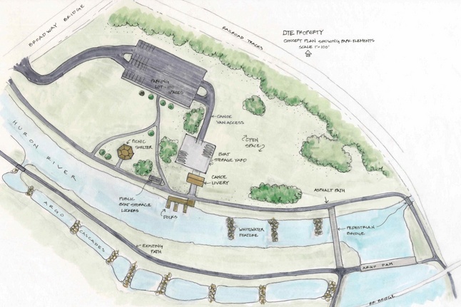
A subcommittee of the city's citizen-led North Main-Huron River Corridor Vision Task Force came up with this working draft plan for a riverfront park on the MichCon site along the Huron River near the Broadway bridges.
City of Ann Arbor
The four subcommittees of the city's North Main-Huron River Corridor Vision Task Force released draft reports this week following months spent brainstorming ideas for improving the corridor and providing better access to recreational amenities along the river.
One of the four reports is focused on repurposing the former MichCon manufactured gas plant site near the Broadway bridges.

Julie Grand
The drawing shows several amenities, including a new canoe livery and docks, picnic shelter, public boat storage lockers, a boat storage yard, a 100-space parking lot and a canoe van access drive.
Grand said an important piece of the plan is a handicap-accessible walking and biking path that follows the edge of the river on the MichCon site and connects Broadway Park to the Border-to-Border Trail.
The drawing also shows the same asphalt path connecting to a proposed pedestrian bridge that would cross over the river from the MichCon site to Argo Park near Argo Dam, connecting with the Argo Canoe Livery, Argo Cascades and other paths that follow the river around Argo Pond.
DTE Energy, which owns the MichCon property, recently completed an environmental cleanup along the river and has indicated a willingness to set aside a portion of the site for public open space.
The company also has asked interested developers to submit ideas for developing part of the site, so it's possible a mix of uses could share the property — some public, some private.
The task force subcommittee recommends the city's staff maintain close talks with DTE representatives as they review options for development.
"If either short- or long-term solutions are to be pursued, city staff should devise a robust process for public input and engagement," the report states. "Public and private funding should be sought for the construction and maintenance of short- and long-term solutions."
Expanding livery operations
The report notes the Argo Canoe Livery, where the city already rents out kayaks, canoes and tubes for trips down the river, often operates at or above capacity due to its popularity.
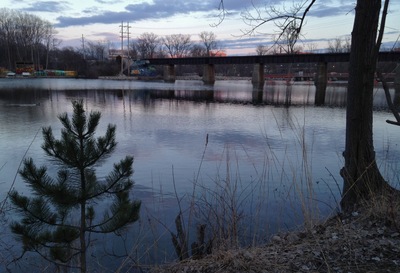
Argo Pond as it looked Wednesday evening with the Argo Canoe Livery off in the distance across the river.
Ryan J. Stanton | AnnArbor.com
Kayaks would continue to be rented from the Argo livery, while those interested in canoeing could begin their trip at the proposed livery on the MichCon site. Grand said that helps deal with the fact that canoes cannot go down the new Argo Cascades, a series of drop pools near Argo Dam.
If planned whitewater amenities next to the MichCon site are approved by the state, Grand said, the second livery would be ideally located for special whitewater classes and rentals. The public boat storage lockers shown in the plans are being requested by residents.
Grand stressed the plans are purely conceptual and any decisions regarding potential recreational amenities on the site would occur following a robust public input process. She said the amenities are shown to scale, but their placement could be modified.
Beyond water-based recreation, the MichCon site has the potential for both formal and informal gatherings, the report states.
"Shelter and pavilion rentals are a popular and increasing significant source of revenue for the parks and recreation department," the report states. "The development of a pavilion, along with adequate open space, would enable a wide range of events."
In order for residents and out-of-town visitors to effectively use the proposed amenities, vehicular access from Broadway Street and a 100-space parking lot is recommended.
"Parking at Argo is already stretched, and parks currently lease private property to help accommodate the need for additional spaces," the report notes.
DTE's plans for the site
DTE Energy set a March 15 deadline for initial submittals from developers interested in the MichCon site. It has asked for creative financing strategies using public and private funding.
According to DTE, the goal in developing the site is to bring about a first-class, mixed-use development capitalizing on the unique features of the riverside property, and incorporating significant green space open to the public.
DTE has expressed interest in a development that could possibly include restaurant, retail, residential, commercial office space and medical office uses.
AnnArbor.com has asked DTE for a summary of the responses it received from developers and its latest thoughts on the future of the site. A spokeswoman said DTE would respond Monday.
Ann Arbor developer Peter Allen confirmed he submitted a response to DTE, but he said he's not ready to talk about it publicly at this point.
According to the subcommittee report, it appears the undeveloped western portion of the site is a strong candidate for expansion of both active and passive recreational activities.
The report contemplates the possibility of public-private partnerships, in conjunction with private development or through civic donations, to fund development and maintenance of the recreational amenities described. There also could be opportunities for grant funding.
The report cautions reconfiguring the site to allow for hundreds of additional vehicles off Broadway Street could prove to be a considerable impediment, and the need for and cost of additional soil remediation to allow active recreation on the site remains unknown.
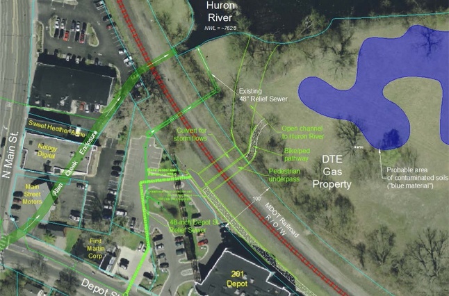
An annotated map of the MichCon site shows possibilities for a pedestrian tunnel under the railroad tracks. This also includes options for improved stormwater flow from the Depot Street side of the tracks to the river to mitigate flooding in the area.
City of Ann Arbor
Getting beyond the tracks
The task force has looked at options for a tunnel for pedestrians and stormwater to pass underneath the railroad tracks to access the MichCon site from Depot Street and North Main.
The report references the Allen Creek Railroad Berm Feasibility Study, which has identified two potential options for underground crossings near the Fourth and Depot intersection.
The Michigan Department of Transportation has acquired these railroad tracks from Norfolk Southern. There's a concern now that as MDOT moves ahead with track improvements for high-speed rail, MDOT could shut down this at-grade crossing at Lake Shore Drive off North Main on the west side of the river, severing the only legal crossing in the area.
Ryan J. Stanton | AnnArbor.com
But in order to apply for federal flood-mitigation grant funding, the benefit of the mitigation needs to exceed the cost, which is not the case based on preliminary analysis, Grand said. So the city doesn't think it would be eligible for FEMA funding, which Grand considers "a serious barrier."
Task force members argue the most significant barriers to creating a pedestrian connection to the MichCon property are costs and the need for cooperation with railroad ownership.
The Michigan Department of Transportation has acquired the tracks from Norfolk Southern. There's a concern now that as MDOT moves ahead with track improvements for high-speed rail, MDOT could shut down the at-grade crossing at Lake Shore Drive off North Main on the west side of the river.
That crossing, located near Bandemer Park, is used by rowers and many others to access the river and the recreational amenities surrounding it, including the Border-to-Border Trail.
Grand said MDOT has taken a position against at-grade crossings such as the one at Lake Shore Drive, which task force members pointed out is the only legal way to cross the tracks there.
If a barrier along the rail line is erected to prohibit pedestrian crossings, the need for an alternate solution greatly increases, and it could cost millions, according to early projections.
It's believed it would be tough to sell the idea of an underground crossing to MDOT, which is concerned about disruptions to rail service and long-term maintenance of crossings.
The task force has identified potential for another crossing that would take pedestrians and cyclists above the railroad from Main Street to the western side of the MichCon site.
Public input sought
The City Council created the citizen-led North Main-Huron River Vision Task Force to develop a vision to enhance pedestrian and bicycle connections from downtown Ann Arbor to Bandemer Park and Huron River Drive, increase public access to the riverside amenities of existing parks along the North Main-Huron River corridor, ease traffic congestion at Main and Depot streets at certain times of day, and recommend use of the MichCon property off Broadway Street.
The task force also has worked on a conceptual plan for the best use of city-owned property at 721 N. Main, which could become a greenway park with new trail connections.
The task force is expected to submit a final report to the City Council by July 31. David Santacroce, chairman of the task force, said there will be chances to provide input at community meetings on May 22 and June 12 from 6:30 p.m. to 8:30 p.m. at the Ann Arbor Community Center.
"I did the math the other day and we've probably got 500 person hours already into this process, so it's important that people get involved now rather than after the fact," he said.
"This has been a citizens group and a citizens task force, and we've got a lot of people involved," he added. "We're now coming up with a product and we want to get more people involved."
AnnArbor.com will have a report on Sunday on the ideas that came out of the other task force subcommittees, including discussion of potential improvements on North Main.
Ryan J. Stanton covers government and politics for AnnArbor.com. Reach him at ryanstanton@annarbor.com or 734-623-2529. You also can follow him on Twitter or subscribe to AnnArbor.com's email newsletters.
Comments
bmulligan
Mon, Jul 1, 2013 : 1:28 a.m.
I used to live within walking distance from here and yet It also took me a minute to realize this map was upside down. I've always known some Ann Arborites thought up was down and down was up, now I have proof. The Ann Arbor Cascades absolutely qualify as a Class II rapids. Regardless of how much training and certificates Mr So-and-so has received, qualifying these chutes as anything less than Class II is irresponsible and overestimating the abilities of novice paddlers. They may be man-made and have ample space between them, but the flow they create, while tame to swimmers in a floatie, can be dangerous for a paddler piloting a boat. The most dangerous drop was the last chute in the cascade. Almost qualifying as a falls, it was a heavy 3 foot drop with a strong standing wave. I witnessed many in kayaks and canoes bottom out, broach, and be swamped or ejected. Sometimes with injury. And lets be honest, the problem was more than likely an injury liability issue more than a few dented canoes. The canoe portage issue should be re-thought by the rule makers, though. Since the demolition and reconditioning of the DTE site SOUTH of the river, the last chute has been reworked and reduced to no more than a riffle, making the cascades more than safe from damage or injury. And since canoes should now have safe passage, the idea of another livery at the bottom is moot. Save your tax money Ann Arborites, you don't need this.
hmsp
Sat, Mar 30, 2013 : 2:46 p.m.
@ Patricia Lesko, re: "Have you seen those boulders on the left on just after the Broadway Bridge?!? LOL. Lots of renters obviously did not." No, they saw them, but here's what they did: Seeing an obstruction on the left, they pointed the canoe over to the right. But the current was taking them towards the boulder faster than they liked, so they started paddling backwards to slow their progress. OK, stop right there. Pretend you are parallel-parking a car: You point the car off to the left, and put it into reverse. Hey, wait a minute! The car was pointed left, and it moved to the right, closer to the curb? How can that be? But that is exactly the thought process of an inexperienced paddler. On a pond, they could probably figure out that paddling backwards with the stern of the boat pointed left will take them left, but on moving water, they paddle themselves straight up onto the rocks. I've seen it a hundred times. If you are really in a situation where you are coming upon an obstacle too fast, point the STERN of the boat to the side of the river you wish to move towards, and paddle backwards. The bow of your boat will be pointing in the direction you DON'T want to go, but, Hey! You're paddling backwards, aren't you? So you'll drift gently across the river in slow motion (it's called back-ferrying) until your way is clear. Then head on downstream. But once again, the irony of the situation is that the canoe-livery business is based on renting canoes to people who don't know how to paddle. So the City should either get out of the business, or stop complaining that their boats are getting scratched.
hmsp
Sat, Mar 30, 2013 : 2:27 p.m.
@ Patricia Lesko, re: "the feature was supposed to have been constructed so that canoes could bypass Argo Dam using the reconstructed headrace, no portage. They can't." They can't because the City changed its mind, and now won't let them. But it is entirely possible to go down that novice channel without incident Re: "People canoed down the rapids with little kids, and their canoes tipped (amid the rocks), got BENT, etc... All of the rental canoes are scratched." I'm shocked! Shocked, I tell you! Rental canoes scratched? Who ever heard of such a thing? Seriously, it is a problem in flat country like this –– people think that they can canoe without knowing how, and for the most part, it works. They get turned sideways, backwards. They yell at each other. But eventually they make it down the river. Learn how to paddle from a real instructor, and those problems go away. Unfortunately, the whole canoe livery industry is built on renting canoes to people who do not know how to paddle. What did the City expect?
hmsp
Sat, Mar 30, 2013 : 1:36 a.m.
Re: "City Parks & Rec manager Colin Smith tested the water course... and reported... that it was a bit more "challenging" than he had expected. Maybe we need to revisit the assumption that "Anybody Can Canoe Without Any Training," a close associate of its corollary, "Anybody Can Drive Without Any Training." That is one of the drawbacks of living around relatively-unchallenging waters. Myself, I trained back in the early 80s down in the Smokies, at the Nantahala Outdoor Center, and that's where I went for my Instructor classes a few years later. And 6-8 years ago, the Madawaska Kanu Centre, up near Algonquin Provincial Park, a few hours North of Toronto, was my family's destination. My teenage daughter and pre-teen son were in kayaks, because of those boats' faster learning curve. My wife and I each paddled our favorite, the solo canoe, the most challenging of all whitewater boats. A lot of drop-per-mile in both of those locales! But here in SE Michigan, the terrain is so flat that nobody thinks they need any training. And then there is a panic, and the "Cascades" are off-limits. Sheesh! How about some paddling classes, eh? And not ones taught by Summer-employed college kids who have never actually paddled themselves! Colin, I've just added you to my "Delhi Challenge" list! Want to go paddling with me, Ryan S, and those Bozo engineers? C'mon, now! It's reality-check time!
Stephen Lange Ranzini
Sun, Mar 31, 2013 : 3:48 a.m.
P.S. Also an awesome place to mountain bike!
Stephen Lange Ranzini
Sun, Mar 31, 2013 : 3:47 a.m.
@hmsp: Algonquin Provincial Park, North of Toronto, *is* an awesome place to canoe and kayak. I did that many summers up there and also heard my first wolf pack howl there, too. An awesome place! Thanks for the trip down memory lane.
andralisa
Fri, Mar 29, 2013 : 7:54 p.m.
Yay! Love it.
hmsp
Fri, Mar 29, 2013 : 7:33 p.m.
Finally, re all of the discussion on the subject of, "they messed up by building something that doesn't work for canoes," and, "it turned out to be impossible thanks to the design," Who says? Mr. Ranzini does a better job of applying critical thinking skills than most people here when he says, "If true, this is a scandal of the first order!" The key phrase being, "if true," which it most definitely is not. Mr. Stanton says, "As I understand it, after a trial run when the Cascades first opened, the city decided it would be safer to not send people in city-rented canoes down the new drop pools." So this knee-jerk decision was not based on the non-existent "difficulty" of this bypass, but apparently on bean-counter issues (scratched canoes) and liability paranoia. So you have to ask how wound-up they'll get if the proposed actual whitewater feature is ever built!
Patricia Lesko
Sat, Mar 30, 2013 : 12:12 p.m.
@hmsp city staffers, and Argo employees told me that canoes were damaged. I live near Argo, and bike the path there regularly. I stopped to chat with staffers several times. The piles of canoes appeared at the end of the bypass, and I asked why. I then called the offices of the company that did the work, and talked to the employee who worked on the project and asked some questions. People canoed down the rapids with little kids, and their canoes tipped (amid the rocks), got BENT, etc....All of the rental canoes are scratched. Have you seen those boulders on the left on just after the Broadway Bridge?!? LOL. Lots of renters obviously did not. Scratched wasn't the issue. Little kids getting tossed into the drink amid rocks, canoes getting stuck, filled with water, bent, etc...were the problems. So, hop on down to Argo when it opens, ask to rent a canoe. They will send you walking 1/3 of a mile down the nice bike path (watch out for the geese) with your life jacket and paddle, water, lunch, etc...You will portage your canoe down a set of crumbling steps to the old put-in, the Argo staffer will help you get in, and off you'll go. Have fun. Watch out for that boulder on the RIGHT, just past the boulders on the left, just after you paddle under the Broadway Bridge. :-)
Stephen Lange Ranzini
Fri, Mar 29, 2013 : 10:33 p.m.
@hmsp: Thanks for the compliment, I think... I do try to fact find first before drawing any firm conclusions. I appreciate your posts - they are very interesting! I think you nailed it on the head when writing "this knee-jerk decision was ... based on ... bean-counter issues (scratched canoes) and liability paranoia. Personally I have the skill to get a canoe down those rapids no problem but I don't own a canoe and rent the city's every time I go, so the city's policy is just about the same as I can't go down there in a canoe anymore. The practical result is the same. AND, with two little kids who can't help carry the canoe, the 1/2 mile portage will not work for me and my family at all. That entire section of the river is I guess now closed off to me and my kids. Bummer!
hmsp
Fri, Mar 29, 2013 : 7:17 p.m.
River Rating, Cont. There is no official entity that rates rivers on a uniform scale. It is done locally, and informally, by the people who actually paddle the rivers. The more challenging the rivers in the area, the higher the skill level of the paddlers, and the better their ability to rate a river. This being the relatively-flat SE Michigan, there are few challenges out there for paddlers, and thus fewer skilled paddlers, none of whose input was sought out in this "rating" process. Rivers are most definitely NOT rated by some engineers with no knowledge of paddling. I would be very surprised if any of the people involved in designing and "rating" the "Cascades" are even possessed of enough paddling skills to simply stay within 50 feet of this senior-citizen greybeard for 5 minutes or so in the mild Delhi Rapids at Spring levels. I'll extend that challenge to Ryan Stanton, as well, who, I believe, fancies himself a paddler. I will be more than happy to go paddling with that group. And perhaps, when we are out there on the river, free of aa.com restraints, some small wagers might be placed, no more than $100 or so per paddler...
hmsp
Fri, Mar 29, 2013 : 7:03 p.m.
OK, that was the short version. Rating the difficulty level of a river is a complex thing. For one thing, different rivers flow at different volumes, measured in measured in Cubic Feet per Second (CFS). The more CFS, the more challenging the river. And the "Cascades" do not even have enough flow to be classified as a river, let alone a whitewater one! The Huron River's two main tributaries, Portage CREEK, and Mill CREEK, each have far more CFS than the "Cascades." Remoteness, with its accompanying difficulty of self-rescue/rescue also factors in. The "Cascades" are hardly in a remote location. I have been saying for a long time that the public was done a disservice when that trickle was named the "Argo Cascades," and the confusion shown in this commenting section is evidence of that.
hmsp
Fri, Mar 29, 2013 : 6:49 p.m.
There is a lot of confusion here about "whitewater. I can be of help here, as I have received extensive whitewater training, including instructor training workshops (I have been certified as a Whitewater Canoeing Instructor by the American Canoe Assoc.), and River Rescue workshops. First off, the "Cascades" ARE NOT A CLASS II SET OF RAPIDS!! Here is the short version of the story, from the American Whitewater Association: CLASS I: Fast moving water with riffles and small waves. Few obstructions, all obvious and easily missed with little training. Risk to swimmers is slight; self-rescue is easy. Bingo! The "Cascades," to a T! CLASS II: Skill level: NOVICE. Straightforward rapids with wide, clear channels which are evident without scouting. Occasional maneuvering may be required, but rocks and medium-sized waves are easily missed by trained paddlers. Swimmers are seldom injured and group assistance, while helpful, is seldom needed. Rapids that are at the upper end of this difficulty range are designated "Class II+". ******** To put this into perspective, the rapids at Delhi never get up to the level of Class II+, even in Spring flood conditions.
Patricia Lesko
Sat, Mar 30, 2013 : noon
@hmsp, I got the Class II rapids classification from the company that constructed the feature and city staffers who interacted with company officials. I'm sure you're right that there are varying definitions of rapids based on a variety of circumstances. Class II on the Racquette River on which we paddled in the Adirondacks last summer was PORTAGE time, no questions. There was very little open space between the rapids. The issue here, isn't the difficulty, per se, it's that the feature was supposed to have been constructed so that canoes could bypass Argo Dam using the reconstructed headrace, no portage. They can't.
My2bits
Fri, Mar 29, 2013 : 6:36 p.m.
The comments here are certainly more political than practical. I live very close to there. The neighborhood loves the cascades. Sure, they messed up by building something that doesn't work for canoes, but we all have adapted and love it. So, we find a way to deal with it and accommodate the canoes better. The DTE site offers great possibilities, but we don't own it. This conceptual plan depends on what DTE does, but it is good to put something forth so that it MAY be contained with the overall plans. Or may not. Ranzini and Lesko should campaign less in this forum.
DJBudSonic
Sat, Mar 30, 2013 : 3:38 p.m.
It doesn't work for all of us, and all of us don't love it, nor have we all adapted to it. I own a canoe, I don't rent, and as such the boat launch at Argo has been cut off from the downriver trip. It is a terrible solution for those of us who used the Argo launch.
Patricia Lesko
Sat, Mar 30, 2013 : 11:55 a.m.
@My2bits the comments here touch on politics because it's politicos who are involved in trying to zone this parcel parkland so that the parkland on Fuller Road (or any of the other parcels of parkland being targeted) may be used for transit. @Bank president Steve Ranzini has provided invaluable insight into city finances. Your expertise, on the other hand, seems to be less obvious. As for "campaigning," Julie Grand is the one running for office, as is my Council member Sabra Briere. If talking about the votes they've cast to use parkland for parking bothers you, maybe you need to start posting comments under your real name so we can all have a better grasp of why you're so very troubled.
Morty Seinfeld
Fri, Mar 29, 2013 : 6:25 p.m.
Where's the skate park for homeless dogs who partake in smoking hash? We must keep all Ann Arbor constituents happy.
LXIX
Fri, Mar 29, 2013 : 5:22 p.m.
It's spring and we are still getting the Hieftje and now the Grand snow job. Who's property will it be? DTE's? They are offering their polluted flood plain property to Risk Profiteers joining palms together with taxpayer monies using the help of rezoning "planners" without any public input? That property is still being heavily taxed right? How about just rezoning it as a suspected toxic site suitable for parking only and let DTE pay the city taxes until they give it away or foreclose. Who wants to pay to insure a for-profit building stuck in mud? Like a McKinley Convention center complete with highrise hotel.? Bunk. No at-grade pedestrian crossing really means no new Train Station there due to parking access over the tracks. More Bunk. Tunnels and bridges are nice but known to be too costly for Ann Arborites so "funding" another park until the station relocates is the Grand scheme of things.. Then after the Fuller move maybe build a City funded Cedar Point profit center complete with Wally world transportation up to historic Howell. Bunk. Take a good look at the track running between Detroit and Chicago. There are lots of pedestrian crossings along the way. Closing those does not win friends and is not how people will ever get re-elected in Lansing. There's even one at Gallop Park over to the expensive Ward 2 neighborhood along Geddes. Where the original Geddes road crossed the river. What about Depot town pedestrians in Ypsilanti. Good luck fencing them off. In Dexter? Chelsea? Jackson? Battle Creek? KZoo? Pure Michigan Bunk. Grade level Train Station parking, BBQ & Beer kiosks, tables along the river, solar power, and, of course, boating amenities. With a big thank you sign posted at the Broadway entrance - Hey, thanks DTE !
Patricia Lesko
Fri, Mar 29, 2013 : 5:14 p.m.
@Steve Ranzini, there was, in essence, no bypass channel constructed with the "addition of white water amenities." There is only a white water course with Class II rapids, which require "experience plus suitable outfit and boat" according to the International Scale of River Difficulty. These updates are from the city's website: http://www.ci.ann-arbor.mi.us/government/Pages/ArgoDam.aspx On Nov. 15, the Ann Arbor City Council passed a resolution awarding a contract to TSP Environmental to design and construct a by-pass channel in the Argo Dam headrace and include the addition of white water amenities. Update 5/17/11: Construction will begin this summer on the bypass channel at Argo Dam. This bypass channel will remove the current canoe portage and when complete, will greatly improve the river trip experience. City Parks & Rec manager Colin Smith tested the water course shortly after it opened, and reported to PAC that it was a bit more "challenging" than he had expected. Initially, rented canoes were allowed down the rapids, but Argo staffers said several canoes were damaged. Then, canoes were piled at the end of the "bypass". Argo-to-Gallup renters walk 1/3rd mile down the asphalt path from Argo Park dragging their lunch, drinks, paddles, life jackets and, yes, kids. Canoes are portaged down a crumbling set of stairs to the put-in by an Argo staffer. Obviously, the toe drains had to be repaired. However, the project was bungled, resulting in exponentially less convenience for canoe renters, particularly those with small children. Kayak and tube rentals are up, however. As kayakers, our family enjoys the rapids, and can go Argo to Gallup without a portage. The thousands who rent canoes at Argo for the Argo-to-Gallup trip start with a 1/3 mile walk and a short portage of their rental canoe to the put-in. The city spent $200K for a canoe bypass and didn't get one.
Stephen Lange Ranzini
Fri, Mar 29, 2013 : 10:39 p.m.
@Pat Lesko: Whatever level rapids they are doesn't matter because the city's policy on canoe rentals screws my family either way. Let me explain. Personally I have the skill to get a canoe down those rapids no problem but I don't own a canoe and rent the city's every time I go, so the city's policy is just about the same as I can't go down there in a canoe anymore. The practical result is the same. AND, with two little kids who can't help carry the canoe, the 1/2 mile portage will not work for me and my family at all. That entire section of the river is I guess now closed off to me and my kids. Bummer!
JRW
Fri, Mar 29, 2013 : 4:32 p.m.
Is the toxic clean-up done?
Tom Whitaker
Fri, Mar 29, 2013 : 4:12 p.m.
Not all of the property at this location belongs to DTE. Across the tracks from the current Amtrak station, the driveway, parking area, and undeveloped area west of the parking area all belongs to Amtrak. East of the parking area is a large area of vacant land next to the tracks, starting under the Broadway bridge and extending a good ways past the Gandy Dancer. This once had a number of siding tracks, removed many years ago. This land is/was railroad (Penn Central - Norfolk Southern) property, assumed to now or soon to belong to the State. This means there is lot's of land to work with in terms of an Amtrak station expansion, Amtrak parking expansion, and/or additional park land, even without the DTE property being included. It seems all the land in this area routinely gets lumped under the DTE heading, and is also routinely assumed to all to be in the flood fringe, but this is not the case.
yohan
Fri, Mar 29, 2013 : 3:11 p.m.
This is a bad location for a canoe livery. The current would make launching and retrieving canoes very difficult. But leave it up to the mayoral rubber stamp commissioners to first build the park and THEN find out it is not suitable, just like the cascades.
aabikes
Fri, Mar 29, 2013 : 3:02 p.m.
Gross, why even bother with a park if you're going to pave over 30% of it.
Stephen Lange Ranzini
Fri, Mar 29, 2013 : 2:44 p.m.
"This canoe livery 'improvement' is the 'fix' to a mistake Grand-led PAC and Council made when approving plans for the rapids. The Argo rapids are Class II, according to the company that made them (the company chosen was inexperienced at building such features), and as such while it was expected canoes would use the rapids, it turned out to be impossible thanks to the design." If true, this is a scandal of the first order! One of the great amenities of living in Ann Arbor is being able to cheaply rent a canoe from a city-owned canoe livery and canoe down a long stretch of the Huron River from Dexter to the dam past Gallup Park. Why isn't AnnArbor.com writing articles about this fiasco and who is responsible?
DJBudSonic
Sat, Mar 30, 2013 : 3:30 p.m.
It is not the rapids, it's the drop into the river that is not allowed by canoe, and rightly so. If you have an 18 foot city rental with 2 people it cannot make the span at the bottom. They will have plenty of broken in half canoes to use for art if they don't fix this pass. I own my canoe and so put in where is is easiest, that used to be the boat launch at Argo, but now that route is closed to me. What should have been an improvement is an impediment, thanks, City!
Stephen Lange Ranzini
Fri, Mar 29, 2013 : 10:36 p.m.
@SonnyDog: It *is* a scandal and it makes me mad! Personally I have the skill to get a canoe down those rapids no problem but I don't own a canoe and rent the city's every time I go, so the city's policy is just about the same as I can't go down there in a canoe anymore. The practical result is the same. AND, with two little kids who can't help carry the canoe, the 1/2 mile portage will not work for me and my family at all. That entire section of the river is I guess now closed off to me and my kids. Bummer!
SonnyDog09
Fri, Mar 29, 2013 : 8:22 p.m.
"this is a scandal of the first order! ... fiasco ... " I love the smell of hyperbole in the afternoon.
Patricia Lesko
Fri, Mar 29, 2013 : 5:20 p.m.
@Ryan, spending $200K for a canoe bypass and not getting what you pay for is a fiasco. This "improvement" sold under the guise of making canoe trips require no portage, failed to do that. Yes, it's good for kayakers and canoeists. This was supposed to be a CANOE bypass with white water amenities. That's not what it is. So, either the public was deceived before the project began or after the project was completed. Take your pick. Either way, staffers who oversaw the project should be held accountable for the need for ANOTHER canoe livery.
Stephen Lange Ranzini
Fri, Mar 29, 2013 : 4:16 p.m.
@Ryan Stanton: I disagree. As you are an avid kayaker I thing you don't understand the perspective from the point of view of a canoeist going from Hudson Mills to Argo Dam. It is a really, really long way to drag your canoe a half of a mile! Who would want to do it now if you aren't allowed to use the river for the length of the Argo Rapids? It works great to launch your canoe you rented from Argo Canoe livery and go downstream, but not if you want to transit the whole river from Dexter Huron Metropolitan Park to Gallup Park Dam.
Ryan J. Stanton
Fri, Mar 29, 2013 : 3:24 p.m.
As I understand it, after a trial run when the Cascades first opened, the city decided it would be safer to not send people in city-rented canoes down the new drop pools. Kayakers and tubers are still going down them in large numbers (so much that the city has to rent additional private parking to accommodate them), and canoes are being launched at a point that avoids the Cascades. Even with the addition of this livery, canoes would be launched at a point that avoids the Cascades. I wouldn't characterize this as a fiasco. Argo Cascades aside, it seems evident there is genuine demand for an expanded livery operation. Whether that means we should use the MichCon site for this expansion is a good discussion to have.
Ryan J. Stanton
Fri, Mar 29, 2013 : 2:35 p.m.
Just to give a sense of how long this issue of access to the river has been a problem, this is from the 1988 North Main Street-Huron River Corridor Land Use Plan: "Existing land uses in the study area include a mixture of industrial, commercial, residential, and public land. One of the most dominant land uses in the corridor is the Conrail right-of- way which runs the entire length of the corridor. These tracks serve as a major barrier to both vehicular and pedestrian access to the Huron River from the south and west. Historically, the presence of the railroad set the early pattern of industrial uses along the river. None of the existing uses are dependent on the railroad. All of them are served by the expressway system and local streets."
AlwaysLate
Fri, Mar 29, 2013 : 2:25 p.m.
Wonderful concept! I hope it materializes. I see a couple of references to the "Broadway Bridges". Is there more than one Broadway Bridge? Or is that one of those localisms…like: I work for "Fords".
Stephen Lange Ranzini
Fri, Mar 29, 2013 : 2:46 p.m.
Yes, there is a railroad bridge AND a bridge across the Huron River. If you take the time to walk across them and explore the very pretty parks on both sides of the bridges you will see what I mean.
Dirty Mouth
Fri, Mar 29, 2013 : 2:05 p.m.
I concur, I support a tunnel for pedestrians and storm water to pass underneath the railroad tracks to access the MichCon site from Depot Street & N. Main. It is logical and should be feasible.
Usual Suspect
Fri, Mar 29, 2013 : 1:59 p.m.
Why is the first map (the drawn one) upside down?
Merlin
Fri, Mar 29, 2013 : 1:59 p.m.
I've lived in Ann arbor for 40 years, and after studying the conceptual drawing of the site for 15 minutes, I was at a loss to figure out where it is. Then I realized that the drawing is upside down. Don't the designers know that the convention is to have North facing upward?
Usual Suspect
Fri, Mar 29, 2013 : 2:18 p.m.
To be fair, A2.com didn't create the map. And if A2.com righted it, then the text would be upside down.
Marc Stephens
Fri, Mar 29, 2013 : 1:47 p.m.
"If a barrier along the rail line is erected to prohibit pedestrian crossings, the need for an alternate solution greatly increases, and it could cost millions, according to early projections." If they 'erect a barrier' along there it had better be a 10-foot tall brick wall. Judging by the 'barrier' fence along the B2B/Arb trail, anything less will be torn open to make way for where people want to travel. Personally, I think a path connecting North Main to Argo Pond, and a 'legal' way to cross the tracks there is a necessary thing.
G. Orwell
Fri, Mar 29, 2013 : 1:43 p.m.
Let's not allow the city to hijack the development of this valuable property. If Ms. Grand does not do what the public wants, she should not have a seat on the city council. All she will do is rubber stamp whatever the mayor wants. The train station expansion should be on the table for any improvements to this site. Private developments on this site would benefit greatly with the train station remaining and expanding at the current location.
a2cents
Fri, Mar 29, 2013 : 1:39 p.m.
I see 2 tunnels in our future... grade xings near curves are an accident waiting to happen, but proximity to the station will keep train speeds low.
Gerry
Fri, Mar 29, 2013 : 1:38 p.m.
Intriguing idea...
Alan Goldsmith
Fri, Mar 29, 2013 : 1:37 p.m.
"Do Julie Grand and Ward 1 Council member Sabra Briere have stock in some asphalt company, or maybe a friend who owns one? Both voted to help Hieftje use parkland for parking on Fuller Road and now this (CM Briere is on the North Main Task Force)?" Guessing Grand's commitment to 'parks' is strong as long as it doesn't conflict with stealing public land without a public vote ala the Fuller Road station. In that situation she was just another puppet for the Mayor and forces for development and lack of transparency.
Jamie Pitts
Fri, Mar 29, 2013 : 1:27 p.m.
It is going to be great to see this area developed with new public amenities, and this process will hopefully continue down Main St. all of the way to the freeway entrance. This particular convergence of citizens, city gov. folks, and private industry seems to be balancing the real needs of the people of Ann Arbor!
Dave the guitar player
Fri, Mar 29, 2013 : 1:25 p.m.
I just want to stress that any property along the river is special and any opportunity to make that land available to the public as parkland is smart (due to flooding) and will enhance the lives of Ann Arborites. That said, I would not be against mixed use of the property (train station, apartments, shops, offices, etc.) as long as the riverside itself is a park and the other uses do not conflict with that goal.
hmsp
Fri, Mar 29, 2013 : 1:16 p.m.
The first drawing that I saw, a few years back, showed the toxic Allen Creek flow kept separate from the main river to protect the whitewater paddlers. Are there any other plans out there that retain this important feature? The water quality of the Huron River drops dramatically at this point, and there are many of us who only paddle upstream of Ann Arbor because of the noticeable difference.
hmsp
Fri, Mar 29, 2013 : 1:09 p.m.
"the fact that canoes cannot go down the new Argo Cascades..." They poured all of that ugly concrete expressly for the purpose of creating a novice-friendly alternative to having to portage around the dam, and now the liveries won't allow their canoes down the grandiosely-named "Cascades." Sheesh! They couldn't have dumbed it down more, so what's the problem? Did they know beforehand that livery canoes wouldn't be allowed? Who made that decision? Not that I care personally about the ban –– I've got my own boats, so I can paddle where I want –– but I hate to see all of that concrete for no good reason.
Usual Suspect
Fri, Mar 29, 2013 : 2:08 p.m.
"Who made that decision?" Look for a Subaru with a kayak rack on top. It was likely one of them.
DJBudSonic
Fri, Mar 29, 2013 : 1:07 p.m.
This space should be considered for train station expansion. Public input IS desperately needed, but mostly NOT WELCOME at these meetings. Examples? For Wednesday's 5 p.m. meeting, the agenda and meeting notice was distributed by email at 4:50 p.m. Wednesday, the same day. So if you wanted to attend, but we're unsure of the topics, you had 10 minutes notice. Is that fair notice? Please attend these task force meetings. You will see that land use ideas are completely guided and predetermined by a handful of mayoral appointees. Public input is treated as a necessary evil. Why else would there be NO consideration of this property use as a train station expansion? It abuts the existing station. It is vacant, utility owned land, not yet parkland. Of course, Ms. Grand is doing all she can to get this zoned as parkland, so the station cannot be placed here. Close a road crossing? No thanks. Allow for a multiple story "mixed use" development to be built with public-private funds? No thanks to that, either.
DJBudSonic
Sat, Mar 30, 2013 : 3:15 p.m.
Look up the list of members and you will see it is indeed populated by a majority of mayoral appointees and their family/friends. Of the 14 members, 8, a majority, are directly involved as a result of council participation or appointment, that is, they were choosen to serve by those appointed by Heiftje. There are a few others whose ties are commercial or familial, in that their spouse works for a business that bids on city contracts, or their employer receives city funds. But don't let the facts get in your way.
ordmad
Fri, Mar 29, 2013 : 5:31 p.m.
Nonsense. One late agenda in 8 months of meetings. And most of the members are NOT mayoral appointments but rather citizens and members of citizens groups. But don't let the facts get in your way.
Usual Suspect
Fri, Mar 29, 2013 : 2:06 p.m.
The reason they don't want public input is that the public would realize this is the best place for a train station, and they want it at Fuller, and they're going to do whatever it takes to get what they want. This is the only location that has access to both railroads in one place, and is therefore the obvious location for a train station. But building it at this location wouldn't scratch the back of the University - that is, Mayor Conflict-of-interest's employer - so, like public art, those who think they know much more than us will do what they want regardless of the opinion of the people.
Dan1737
Fri, Mar 29, 2013 : 1:06 p.m.
Public boat storage lockers are a wonderful idea! I own a kayak and would love to be able to walk or ride my bike to the park instead of having to put the boat on the roof of my car and drive (or rent a boat). I suspect there'd be enough demand that they'd be able to rent out more storage lockers than there are on this preliminary drawing.
Usual Suspect
Fri, Mar 29, 2013 : 2:10 p.m.
"having to put the boat on the roof of my car and drive (or rent a boat)" I wish I had life as rough as you.
Ryan J. Stanton
Fri, Mar 29, 2013 : 1:10 p.m.
If the price is right, I'd keep my kayak down there, too.
Patricia Lesko
Fri, Mar 29, 2013 : 1 p.m.
Our family lives near Argo, owns 4 kayaks and paddles this stretch regularly (Argo-Barton/Argo to Gallup). A "small canoe livery 1/3 a mile from the one at Argo?" Seriously? Another parking lot? Do Julie Grand and Ward 1 Council member Sabra Briere have stock in some asphalt company, or maybe a friend who owns one? Both voted to help Hieftje use parkland for parking on Fuller Road and now this (CM Briere is on the North Main Task Force)? This "improvement" is the "fix" to a mistake Grand-led PAC and Council made when approving plans for the rapids. The Argo rapids are Class II, according to the company that made them (the company chosen was inexperienced at building such features), and as such while it was expected canoes would use the rapids, it turned out to be impossible thanks to the design. Ok. Better for the kayakers and tubers. Now, Grand and Council member Sabra Briere want to build a canoe livery 1/3 mile away from the one at Argo AND parking for 100 cars? We need keep oil run-off and other contaminants away from the river. DTE just spent $2-$3M scraping contaminated soil off that former parking lot site. Build our new livery at Riverside Park, where there are going to to be TWO parking towers built by U of M nearby, and there is already a 100 car parking lot. There's a bike path, playground, picnic tables, open space, etc...A restaurant near that stretch of the river would be near the U of M mega-development, and the apartment towers, Kellogg Eye Center, etc.... Here's an idea for the DTE site: How about a facility on that site where residents could pay a small fee to store their canoes and kayaks and other equipment? How about trees on that site next to the river, to replace the ones that were ripped out? Trees help with flooding, yes? How about a natural beach and safe swimming area, so people stop swimming in the rapids? How about a dog park? I dunno. How about something that's not parking?
Patricia Lesko
Fri, Mar 29, 2013 : 5:31 p.m.
@bluetonguedlizard, maybe I just have some kind of amazing parking karma, but when we take our kayaks to put-in at Argo on the weekend, I always find the spot right next to the public put-in empty. However, I have seen the lot next to the livery full, and folks parked up Longshore. Bandemer Park, on Barton Drive, is a GREAT put-in spot with plenty of parking, but only for those with their own boats. We've also been exploring the river in Ypsi. Peninsular Park to the Superior Dam was an absolutely amazing paddle. Imagine a full day Delhi to Ypsilanti paddle with a little stop over for lunch in Riverside Park? The two cities could collaborate on a trip/livery for Peninsular Park, which Ypsi is spending $90K to upgrade (much needed). Lots of possibilities.
bluetonguedlizard
Fri, Mar 29, 2013 : 5:12 p.m.
I see your points, my one comment would be that parking at Argo is a NIGHTMARE on the weekends and I don't see how they can enlarge the current parking situation there.
My2bits
Fri, Mar 29, 2013 : 1:57 p.m.
Having the two liveries very near each other actually IS a good idea, as some amenities can be shared. Just envision it as one bigger livery with different structures for renting canoes, kayaks, snack bar, bathrooms... The vans that pick up and drop off people and watercraft would be concentrated here and at Gallup (and Delhi?)
halflight
Fri, Mar 29, 2013 : 1:29 p.m.
Plus, there's the inefficiency of running two boat liveries instead of one. If Argo is too small, move all of the livery to the DTE site, or expand Argo. Don't intentionally plan two liveries that will necessitate more employees and raise the cost of the livery service.
hmsp
Fri, Mar 29, 2013 : 12:54 p.m.
It would be ironic if the loudest voice against doing the right thing, and removing the dam –– the rowing crowd –– ended up being denied access because of their grade crossing.
Kai Petainen
Fri, Mar 29, 2013 : 12:41 p.m.
I love the tunnel idea and I love the new livery idea! Sweet ideas!
JimmyD
Fri, Mar 29, 2013 : 12:38 p.m.
I hope sanity wins and we don't get stuck with the bill for an expensive bridge or tunnel (which both have user risks). Just clean up the pedestrian with lights/gate/bell just like they do all over the world. Enough with the Nanny-State.
ordmad
Fri, Mar 29, 2013 : 5:27 p.m.
Says the man that employs scores of them when they suit his interests.
Stephen Lange Ranzini
Fri, Mar 29, 2013 : 12:53 p.m.
@JimmyD: If MDOT and the railroads that use that track are willing to do that, you are correct that it would be a more cost efficient and cheaper solution. It is actually my preferred option, but don't think they will agree due to the perceived legal risk. Our country has too many lawyers in charge and not enough Common Sense!
Craig Lounsbury
Fri, Mar 29, 2013 : 12:21 p.m.
Looking at statistics on rail deaths at crossings the truth is they are pretty small in number. Most are pretty much avoidable and the clear fault of the driver/pedestrian. So I contend the need for a pedestrian tunnel in the big scheme is practically nonexistent. Its an expensive solution in search of a problem.
timjbd
Sat, Mar 30, 2013 : 5:48 p.m.
Don't have to USE it, just has to be there FOR use.
SonnyDog09
Fri, Mar 29, 2013 : 3:23 p.m.
What makes anyone think that the pedestrians of A2 who never cross the streets at a cross-walk will use a tunnel? Folks will continue to cross the railroad tracks wherever the heck they want, just like they cross the streets wherever they want. Don't waste money building a tunnel that pedestrians will not use.
Stephen Lange Ranzini
Fri, Mar 29, 2013 : 2:34 p.m.
@Craig Lounsbury wrote: "We need a tunnel to protect us from lawyers." We are in complete agreement Craig on that and the rest of your post. It is a total waste of money, but unfortunately we must deal in the practical way the world is, not what it ought to be. Since a crossing is needed if we can't get one at grade with a modern pedestrian rail gate, we need a tunnel, because a tunnel is way cheaper than a bridge.
a2cents
Fri, Mar 29, 2013 : 1:36 p.m.
a persuasive argument for darwin
Craig Lounsbury
Fri, Mar 29, 2013 : 1:14 p.m.
The liability issue speaks to my point. The actual problem, people dying at railroad crossings barely exists. The real problem is the fear of getting sued by a lawyer. We are discussing the "need" for a pedestrian tunnel not to kepp pedestrians from dying, we are discussing a pedestrian tunnel because we have more lawyers and more litigation per capita than anyplace else in the world. We need a tunnel to protect us from lawyers.
Stephen Lange Ranzini
Fri, Mar 29, 2013 : 12:58 p.m.
For perceived liability reasons, MDOT would already like to close the at grade crossing of the railroad at Lake Shore Drive which is the sole public legal access to Bandemer Park. They don't want to add any at grade rail crossings. While I agree it is doable with a modern pedestrian rail gate, it would be a tough sale to MDOT and the railroads that have the legal right to use those tracks.
amlive
Fri, Mar 29, 2013 : 12:37 p.m.
I agree with your first part, but real problems still do exist. Those real problems seem not to be ones of demonstratable risk or safety concerns, but rather of railroad property vs public easements. Purely legal problems based on virtually nonexistent (or at least easily addressed) tangible problems, but problems none the less.
bluetonguedlizard
Fri, Mar 29, 2013 : 12:15 p.m.
A cafe or similar would be great also!
Arboriginal
Fri, Mar 29, 2013 : 12:08 p.m.
I am looking forward to the Peter Allen proposal.
DJBudSonic
Fri, Mar 29, 2013 : 12:56 p.m.
Do you know about his pedestrian bridge ideas? They seem cool and affordable, but I have not heard anything about them outside of the task force meetings.
Ryan J. Stanton
Fri, Mar 29, 2013 : 12:55 p.m.
Me, too. He's a big thinker and he's got a big stake in that area already.
Ryan J. Stanton
Fri, Mar 29, 2013 : 11:52 a.m.
It strikes me that no matter what challenges lie ahead with the MichCon site, and regardless of whether all this comes to fruition in the long-term, the city at the very least in the short-term should be able to see the realization of that path along the river's edge and the connections to the other side of the river, which I think just about anyone who's been out there knows would be a major improvement. Agreed?
amlive
Fri, Mar 29, 2013 : 11:20 a.m.
"There's a concern now that as MDOT moves ahead with track improvements for high-speed rail, MDOT could shut down the at-grade crossing at Lake Shore Drive off North Main on the west side of the river." What???! If laws regarding railroads, easements, public access, or whatever it falls under would allow for this, that is patently absurd. Whether by legislation or lawsuit, rights of the public vs railroad (private or publicly owned) seem long overdue for a revisit. The tracks already impede public access to our river essentially along it's whole south/west border to the downtown area. This is bad enough, but to hear that MDOT may have the power to shut down the only (and already insufficient) western access is simply appalling. The park proposal looks great to me, but it sounds like the biggest hurdle in successfully reconnecting our town to it's river may be getting past the tracks.
gbob
Fri, Mar 29, 2013 : 2:05 p.m.
MDOT should not cut off access to parkland. Some of the parks along the river were purchased and improved using State of Mich grant funds. If high speed rail is to be constructed along the river existing pedestrian crossings need to be accomodated and new ones provided at locations where tresspassing occurs on a regular basis. The cost for these needs to be a part of the RR upgrades. Otherwise it would be like building I-94 right next to the river.
Arboriginal
Fri, Mar 29, 2013 : 11:03 a.m.
Train station.
Arboriginal
Fri, Mar 29, 2013 : 11:04 a.m.
Intermodal transportation hub thingy.
RUKiddingMe
Fri, Mar 29, 2013 : 10:55 a.m.
I'm excited to see what comes of this, although the mention of "public funding" makes me shudder to think of how poorly A2 leaders do with money right now. I hope it won't be prohibitely expensive to clean up that area in the drawing between the Pedestrian Brige and the dam; a big portion of that looks to be a soup of toxic poison straight out of a B movie. I mean it is NASTY. Since the city throwing millions of dollars at a train station seems unavoidable, without any sense or decency, it seems like the lesser of 2 evils would be to concentrate all money and efforts on the CURRENT station. Having a stop at a nice facility here would be a gorgeous welcome to Ann Arbor for visitors and residents alike. If you took all the money spent on studies, consultants, wasted preparations, etc. and focused it on something that at least might make sense when all's said and done, I can't think of a better idea than an improved station right where it is, with this lovely piece of land (at least as it's envisioned above) and improved river space the first thing you see when disembarking. A great place to wait for the train or relax between stops or a beautiful first glimpse of what Ann Arbor SHOULD look like. Fix some of the roads, get this space greened up and have something useful there, and this could be a really good finished product. Stop wasting time and money, make the commitment to something that makes sense, and do it.
Stephen Lange Ranzini
Fri, Mar 29, 2013 : 10:52 a.m.
Sorry the article link was chopped off at the end of my earlier post. The correct link is: www.annarbor.com/news/ann-arbor-spending-50k-to-study-feasibility-of-pedestrian-tunnel-under-railroad-tracks-behind-depot/
Stephen Lange Ranzini
Fri, Mar 29, 2013 : 2:09 p.m.
@Kai Petainen: I like and do use www.tinyurl (I think you clued me into it two years ago!) if the link doesn't properly post (long urls without a "-" in them don't post properly on AnnArbor.com), but in this case it was the 2,000 character limit on a post kicking in without warning. I thought I had room and when I posted it, it chopped off the last line.
Kai Petainen
Fri, Mar 29, 2013 : 12:42 p.m.
Stephen... use tinyurl for long links.
Stephen Lange Ranzini
Fri, Mar 29, 2013 : 10:47 a.m.
I strongly support & see multiple benefits of a tunnel for pedestrians & storm water to pass underneath the railroad tracks to access the MichCon site from Depot Street & N. Main. We need pedestrian access to the cross border trail from the N. Main St. area at Depot St. to get pedestrian access to this key community riverside amenity. A tunnel is a lot less expensive than a pedestrian bridge. "The railroad berm near the outlet of Allen Creek is oriented perpendicular to the overland flow of the creek & causes the floodplain depth to be as deep as 10 feet," Hancock said. "In addition, the area upstream of the berm experiences flood depths typically in the three- to five-foot range." "Hancock said there are "numerous structures within the influence of the railroad berm" located near the mouth of Allen Creek. If the berm could be opened up enough to restore the floodplain to its more typical depth, he said, some structures might not be in the resulting smaller floodplain. Structures that would remain in the floodplain would experience reduced flood depth & a reduced flood risk, Hancock added." This would provide a strong benefit to the owners of the buildings that would benefit, & a local improvement district could pay for some of the cost equal to the benefit they receive & the city should find the money from a lower priority elsewhere if federal or state funding is not available. Constructing more of the Border to Border Trail with excellent access from Main St. will be an economic boon to the city. Microsoft relocated from Albuquerque, N.M., to Redmond, Wash., early in its corporate existence, for example, primarily because Redmond had the Sammamish River Trail, a 10.9-mile bike path & recreational rail trail. This ought to be a high priority for the city of Ann Arbor. The quotes are from www.annarbor.com/news/ann-arbor-spending-50k-to-study-feasibility-of-pedestrian-tunnel-under-railroad-tracks-
kilroy
Fri, Mar 29, 2013 : 10:39 a.m.
Great story on a great plan Ryan!
Alan Goldsmith
Fri, Mar 29, 2013 : 10:29 a.m.
So now that Grand is running for City Council on the Mayor Puppet Ticket will we continue to be treated to an ever increasing number of stories featuring the candidate without mention of her candidacy?
DJBudSonic
Fri, Mar 29, 2013 : 11:05 p.m.
Yes, to build name recognition in the voting public, in lieu of serving to inform the voting public about the issues that face the city; not least of which is the unnecessary spending spree the current administration and cohorts would like very much to continue.
Gerry
Fri, Mar 29, 2013 : 1:32 p.m.
It's quite clear that this paper is working with the mayor and the New World Order to use Agenda 21 to enslave the population of Ann Arbor and turn over its sovereignty to the United Nations. Or..., it could be that the paper just wants to report the news, regardless of whether it is politically correct to the TEA Party crowd who has the same knee jerk opposition to the mayor at the local level that they do to our president at the national level. Let's just hear the news about one vision for the riverfront, and dump the politics already...
music to my ear
Fri, Mar 29, 2013 : 10:26 a.m.
this would be amazing, ann arbor seems to always find room for growth,however when it comes to parking space that is a different story, why is that? but please no casinos.
music to my ear
Fri, Mar 29, 2013 : 5:19 p.m.
thats a 10 4 buddy @ gonavy.
GoNavy
Fri, Mar 29, 2013 : 11:23 a.m.
There is plenty of parking in Ann Arbor - you simply have to pay for it.