
AVN MOS - hourly predictions from Weather Underground & National Weather Service
One of the first weather maps that I look at in the morning before bundling the kids up and getting them off to school, if I get the time, is the AVN MOS report from Weather Underground. It's an every three hour forecast designed for aviation that tells you not only what the the highs and lows are for the day, but also breaks it down to an every three hour forecast so that you can make a guess whether it will be warm enough to go out on the playground or if it will be snowing hard at school pickup time.
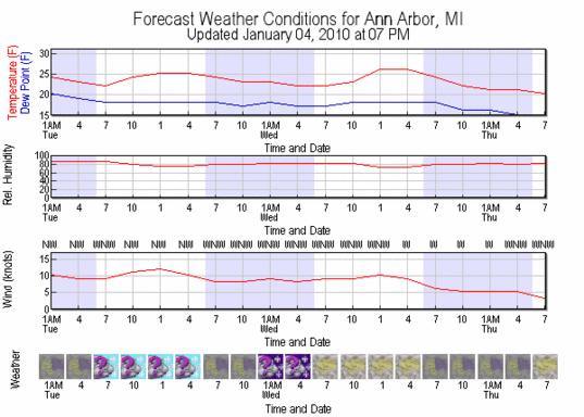
<a href="http://www.wunderground.com/MOS/DisplayMOS.asp?AirportCode=KARB&SafeCityName=Milan&StateCode=MI">Computer Forecast Guidance for weather station KARB</a>, Ann Arbor Municipal Airport, using AVN MOS models.
Courtesy Weather Underground
The Weather Underground graphic is derived from this GFS MOS guidance for KARB, included in all of its informative but cryptic glory:
ANN ARBOR
 KARB   GFS MOS GUIDANCE    1/05/2010  0600 UTC
 DT /JAN   5      /JAN   6                /JAN   7             /
 HR   12 15 18 21 00 03 06 09 12 15 18 21 00 03 06 09 12 15 18 00 06
 X/N              28          19          28          16       23
 TMP  22 24 26 26 24 24 23 22 22 23 26 26 24 22 21 20 19 20 21 20 20
 DPT  18 18 19 19 19 18 18 18 17 18 18 18 18 16 15 14 14 15 16 16 14
 CLD  OV OV OV OV OV OV OV OV OV OV OV OV OV OV OV OV OV OV OV OV OV
 WDR  31 31 31 31 30 30 30 29 29 30 29 28 28 28 28 28 30 32 30 34 33
 WSP  09 10 11 10 08 08 09 09 09 10 10 09 06 05 05 05 03 04 06 06 09
 P06        33    28    29    22    16    10     5     8    21 46 21
 P12              50          29          24          11       46
 Q06         0     0     0     0     0     0     0     0     0  1  0
 Q12               1           0           0           0        1
 T06      0/ 0  0/ 0  0/ 0  0/ 0  0/ 0  0/ 0  0/ 0  0/ 0  1/ 0  0/ 0
 T12                  0/ 0        0/ 0        0/ 0        1/ 0  0/ 0
 POZ   0  0  0  0  0  0  0  0  0  0  0  0  0  0  0  0  0  0  0  0  0
 POS 100100100100100100100100100100100 99100100 98100100 97 97 96 99
 TYP   S  S  S  S  S  S  S  S  S  S  S  S  S  S  S  S  S  S  S  S  S
 SNW                           1                       0
 CIG   4  4  4  5  5  5  5  4  4  5  5  5  6  6  5  5  5  4  4  4  4
 VIS   7  7  7  7  7  7  7  7  7  7  7  7  7  7  7  7  7  4  5  3  4
 OBV   N  N  N  N  N  N  N  N  N  N  N  N  N  N  N  N  N BR  N BR  N
Reading down there's some obvious information (in order: temperature, dewpoint, cloudiness, wind direction, windspeed), and some lists of information that I don't know precisely how to interpret but that I hope that a pilot reading this will help me decode. Also note that the text forecast is a little bit newer than the graphical forecast included above and that it covers a slightly different span of time.
Here's the Weather Underground's description of the AVN MOS information.
The Aviation (AVN) Model Output Statistics (MOS) is a forecast product produced by the National Centers for Environmental Prediction. This forecast product gives detailed weather information in three hour increments spanning the 48 hours after the Aviation Model (A Numerical Weather Prediction Computer Program) is run. The forecast weather information includes temperature, dew point, wind speed and direction, cloud cover and obstructions to visibility, probability of precipitation, precipitation form (rain, sleet, freezing rain, or snow), and probability of severe thunderstorms.
The forecast weather information is derived from equations which relate the forecast output of the AVN to what actually is observed at the forecast location. In other words, a forecast is first taken from the AVN weather model. Based on how accurately this weather model has predicted weather in the past, NCEP has developed equations to skew the model's forecast output to make it more accurate for the location for which a forecast is being produced. The final "skewed" product is the AVN MOS product presented on this web site.
Edward Vielmetti knows well enough to wear a hat and gloves in January without even needing to check the weather forecast. You can find him at AnnArbor.com waiting until the last possible moment to run to catch the bus or reach him by phone at 734-330-2465.