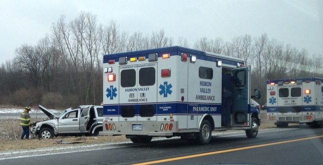
Crash slows traffic on M-14 east of Ann Arbor

Ambulances and firefighters responded to a crash on M-14 near Gotfredson Road Tuesday morning.
Photo courtesy of Lindsay Mumper
A rollover crash on M-14 near Gotfredson Road was slowing traffic on the freeway east of Ann Arbor Tuesday morning.
The crash, believed to have involved just one vehicle, occurred in the westbound lanes, a dispatcher with the Washtenaw County Sheriff’s Office said.
A Google traffic map showed a backup on both sides of the freeway about 9:30 a.m.. Further information was not immediately available.
View M-14 and Gotfredson Road in a larger map


Comments
noyfb
Tue, Mar 19, 2013 : 3:21 p.m.
way to go annarbor.com! using goggle traffic maps as your source. hooray!!! that's old school hard-nose journalism for reelz! where do you think google gets it's traffic from? Do you think goggle has helicopters in the sky over M14? Try MDOT next time.
Kyle Mattson
Tue, Mar 19, 2013 : 4:29 p.m.
Considering the location of the accident noyfb the scene would have been mostly clear by the time a reporter would have made it to the scene from our newsroom here downtown. We would like to use MDOT's information more frequently; however, as noted in this story from last month the camera and online system continues to be delayed for Washtenaw County. http://bit.ly/aadc-wcfway As a result we often do utilize various online tools like Google's GPS based traffic system to get a rough estimate of any back ups as well as reader provided information.
Alec
Tue, Mar 19, 2013 : 4:12 p.m.
Eep is correct
Eep
Tue, Mar 19, 2013 : 3:42 p.m.
Google traffic maps are updated in real time based on GPS data transmitted by mobile phones - they basically track how fast the phones are moving to determine how traffic is moving along the road. From what I understand, they take the GPS data from people with Android phones who have allowed Google to collect the data from the Google Maps mobile application.
jcj
Tue, Mar 19, 2013 : 2:21 p.m.
Crash # 87 in the last year on area freeways, Oh wait maybe its # 23.I guess we will never know.