
Forecasts ahead of today's wild weather: wind, wave and power outage maps
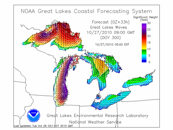
The wave forecast Lake Michigan for early Wednesday morning. High winds from an incoming storm are forecast to generate waves up to 25 feet along the western Michigan shoreline.
Courtesy Great Lakes Coastal Forecasting Center, GLERL, NOAA
A storm with high winds is on its way into the Ann Arbor area. Here are some maps that will help you see the progress of the storm, as well as view some of the aftermath.
Wind maps from Wind Finder

Windfinder's forecast for the Great Lakes shows speeds up to 50 miles per hour in northern Lake Michigan.
Courtesy Windfinder
It's going to be very windy. How windy? I started to look.
What I found was Wind Finder, a global tool for "kitesurfers, windsurfers, surfers, sailors, paragliders and anybody who needs accurate wind data!" The system is based in Europe, and the news on the site is full of kitesurfing competitions in Turkey.
I'm not suggesting that you go kite surfing on Lake Michigan, not today at least; the forecast winds go up to 50 miles per hour.
Links
- Windfinder.mobi, a version of Windfinder designed for mobile phones; see the Saugatuck forecast as an example.
- Windfinder forecast for the Great Lakes. The North Lake Michigan buoy is one that is going to get a lot of wind.
- Weather Underground regional wind map shows current wind conditions across the area.
Wave maps
Where there's wind across the water, there will be waves.
The standard measure for Great Lakes storms is to compare the intensity of the waves to the storm that sunk the Edmund Fitzgerald in 1975. That storm had waves estimated to be as high as 35 feet.
The Great Lakes Coastal Forecasting System produces wave and wind forecasts across the Great Lakes. It uses a combination of weather data including measurements from buoys in the middle of the lakes to track and predict severe weather, and in the winter it also produces ice coverage forecasts.
Links
- The Great Lakes Coastal Forecasting System produces forecasts and collects data across the lakes. See current conditions on a Google map.
- CIMSS at the University of Wisconsin has a weather simulation of the Edmund Fitzgerald storm. From the news release:
- Robert Aune, a scientist with the National Oceanic and Atmospheric Administration (NOAA) stationed at the UW-Madison Space Science and Engineering Center (SSEC), recently created a simulation of the storm that swept across Lake Superior on that November evening. Satellite technology was brand new in 1975, so Aune obtained conventional observations through an ongoing project at the National Center for Environmental Prediction and the National Center for Atmospheric Research that uses modern techniques and technology to reanalyze weather data from 1949 through the present.
Power generation and outage maps
When the wind blows, the power goes out.
The state of the art of electrical utility outage mapping is quite variable. It's common, but not universal, for utility companies to have some kind of regularly updated map of outages, but there is no single universal reporting standard for these, and thus no national outage map.
Utility companies also generate power from wind. The Midwest ISO, which coordinates the management of the power grid in the midwest, tracks current and predicted wind power generation. A Day Ahead Wind Forecast chart shows predicted and actual wind generation for the day; today's projected peak geneation in the region from wind is 6600 megawatts.
Links
- The DTE Energy outage map shows conditions in southeastern Michigan, including Ann Arbor.
- Consumers Energy serves customers in western Michigan. It doesn't have any online outage mapping, though the press releases from the Consumers Energy newsroom are thorough and detailed.
- Indiana Michigan Power serves southwestern Michigan and northern Indiana.
- Duke Energy serves southern Indiana.
- The ComEd Chicago area map shows outages in the Windy City.
Edward Vielmetti checks the weather for AnnArbor.com. For more local weather information, see the AnnArbor.com weather page.
Comments
PittsfieldTwp
Tue, Oct 26, 2010 : 10:54 a.m.
I know there is no scientific link, but I always find it amazing the high wind days are also quite often trash pickup days in my sub.
Patti Smith
Tue, Oct 26, 2010 : 10:24 a.m.
Thanks for putting this out, Ed. It is very windy here in SW Detroit, as the kids take their make up MEAPS (amidst tornado drills--just drills for now!)