Did you hear the sirens on Tuesday? A look at siren testing results in Ann Arbor

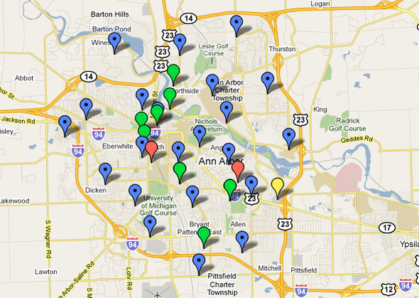
Sirens (marked in blue) are tested on the second Tuesday of the month in Ann Arbor at 1 p.m. Listening reports show where sirens are easy to hear (green), difficult to hear (yellow), or could not be heard (red).
Edward Vielmetti | AnnArbor.com
The City of Ann Arbor tested its siren system on Tuesday, a routine which it does every second Tuesday of the month between March and November. The map shows where the sirens are, and the red dots indicate the locations where people who expected to hear the sirens didn't hear them.
Local siren testing
The City of Ann Arbor's Siren Warning System is tested March through November on the second Tuesday of each month at 1 p.m. with a one-minute tone.
There are 22 siren locations listed by the city, and a map shows their approximate locations.
The Washtenaw County Emergency Management Division tests its sirens at noon on the first Saturday of every month between March and September.
How these are activated
Radio Reference is a comprehensive database of scanners, radio call signs and transmitter information and other public safety and utility radio information. Its listings for Washtenaw County include a reference to call sign KQB271 with a note that it is used for outdoor sirens. The FCC license for KQB271 shows that it is registered to the City of Ann Arbor, but provides no further details.
Mapping
The map at the top of this story was done with Google Maps, using reports received from area citizens. Google Maps is good for putting together a quick map of information, especially when you already have a pretty good idea where things are.
A similar map of the impact of the Kalamazoo soil spill has been harder to put together, in part because when I started working on it I was not as familiar with the geography of the area.
DTE energy has a new power outage map, which replaces an old PDF which only gave you information at the zip code level with a new report that lets you zero in on each outage. The real test of this will be during a severe weather event.
A new platform called Crowdmap was designed to solve the problem of crowd-sourced maps:
"Crowdmap is designed and built by the people behind Ushahidi, a platform that was originally built to crowdsource crisis information. As the platform has evolved, so have its uses. Crowdmap allows you to set up your own deployment of Ushahidi without having to install it on your own web server."
Crowdmap had a few days of system instability at its first launch, so I didn't use it for this map. Look for a test of it as a news gathering tool during a crisis soon — after all, football season is only a few weeks away.
Edward Vielmetti makes maps for AnnArbor.com


Comments
breadman
Wed, Aug 11, 2010 : 11:34 a.m.
What sirens? Where I live you can not hear them inside. So far so few. If a storm rolls in, its best to come knock on my door at lease we can hear that, but not a siren....
Susan Montgomery
Wed, Aug 11, 2010 : 10:51 a.m.
Is there a way for us to add our markers to the map?
StrongFire
Wed, Aug 11, 2010 : 10:20 a.m.
Please note that the sirens are an outdoor warning system. It is primarily intended to be heard outdoors. If you mark difficult to hear or could not be heard, please make sure that these are outdoor observations. WeatherAlert radios are best for an indoor warning system.