
On dividing the city of Ann Arbor into parts
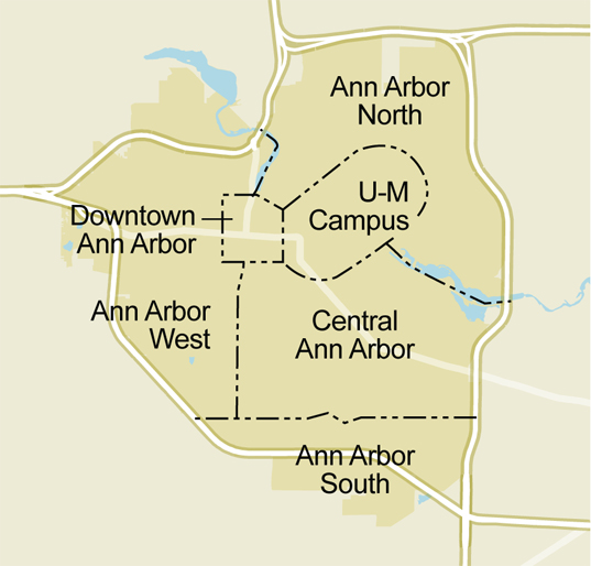
Last week, we launched six new neighborhood pages on AnnArbor.com: Downtown Ann Arbor, Central Ann Arbor, Ann Arbor's West Side, Ann Arbor's South Side, Ann Arbor's North Side and UM Campus.
As we've been working on these new pages, I've been looking maps of Ann Arbor to make sense of where everything is. Â The more I look, and the better the technical quality of the map, the more confusing it is.
The easiest map to look at is the city boundary. You'd hope that it was as simple as the freeway ring around Ann Arbor, but you'd be wrong. There are neighborhoods to the west and to the south of the highways that are within the city limits; on the other hand, there are little islands of the townships sprinkled throughout the city, especially near the Arboretum and along the north side of town. Â Â
The political map of town is just as complicated. Unless you're actually on City Council, you probably don't know where the Third Ward ends and where Fourth Ward begins. Â Look too closely, and you puzzle over how on earth it came to be that one side of Greenwood Street is in the Third Ward, and the other side is in the Fourth Ward; that should however come handy next time you want to throw a block party there.
Parks serve to rally neighbors around an adopt-a-park program or a spring egg hunt in the park or a local favorite sledding hill. Â The city has 157 parks, ranging from the vast riverside expanse of Gallup Park to the tiny neighborhood pocket parks like Postman's Rest Park, Mushroom Park, and Belize Park. Ann Arbor is too big to assume that everyone knows where every park is. The most famous park on the south side of campus isn't even known by its name at all; George Washington Park is the site of The Rock, perpetually drenched with paint in open defiance of the city's municipal graffiti ordinance.
If you have kids, you know what school they go to, and for the most part the Ann Arbor schools are neighborhood schools. When you look at the detailed map of elementary school assignments you start to see another crazy quilt map of busing patterns, bringing kids in from the edges of town to the schools closer to the middle, and not always resulting in easy to understand boundaries. The new Skyline High caused high school boundaries to be redrawn, with predictable map complications.Â
The city keeps a list of neighborhood associations. Many of them were created for a specific purpose like fighting the city on some zoning, parking, or development issue, and there are over 200 of them that the city once knew about but hasn't necessarily kept up with current contact information over time.
After months of search, we think we have come up with a way to section the city to help us better divide things up so that we can continue our focus on neighborhood issues without getting to micro-local.
Mailing addresses in Ann Arbor, and across the whole country, have zip codes. In this area, the zip code boundaries are compact enough and more or less logical enough to serve as a quick way to divide the city into reasonably coherent parts. The 48103 zip code is the west side, 48105 is the north side, 48108 is the south side, and whatever left over in the center is 48104, except for the University, which is 48109.
If you squint too hard at the zip code map, you get the same kind of crazy borders that you were hoping to avoid. Â The Carpenter Road corridor, for example, switches from Ypsilanti to Ann Arbor at a point not memorialized by any marker. Â East Ann Arbor was incorporated as its own city in 1947 complete with a police force; it was annexed to Ann Arbor in 1956 before it got a chance to get its own zip code. Â All of the Ann Arbor zip codes extend at some point into surrounding townships, and the zip codes don't line up with school district boundaries.
Zip codes have a peculiar appeal to modern computer systems, which makes them a good next step in the evolution of our neighborhood coverage. We will be using this to help us quickly cluster together stories and news from around town so that we can make sense of what's going on where you live.
Edward Vielmetti writes about neighborhoods for AnnArbor.com. Contact him at 734-330-2465.
Comments
IndyA2
Mon, Mar 1, 2010 : 3:24 p.m.
Ed: I must have been sleeping because I can't find any "border" details on the admittedly arbitrary boundaries, particularly trying to figure out if I'm in "your" Downtown or West. Where's the web-oriented click-to-map that details those AnnArbor.COM boundaries? Trying to extrapolate, it looks like "Downtown" is approximately First x West Summit/Fuller x State x William? Thanks.