
New data set from city shows free digital maps of Ann Arbor and Washtenaw County
Part of the release of new data sets from the City of Ann Arbor is a set of maps, in digital form. Here's a view of each of them, so that you can see what's there and how you might use them in your own mapping efforts.
The maps are provided in two formats: a KML format, which is usable by Google Earth, and a shape file format, which is usable by GIS programs. KML is also readable within several online map systems like Google Maps, and the examples I will show will come from that.
Boundary maps
The most basic of all of the maps is the Ann Arbor city boundary map, which shows the current boundaries of the city. You will note that there is a very ragged edge between the city and surrounding townships, and there are a number of township islands inside the city limits.
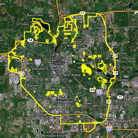
The municipal boundaries of Ann Arbor are not a simple straight line.
City of Ann Arbor, Google Maps
Plans under review
The city publishes a feed of Petitions Under Review, showing requests for approval from city departments for construction and development.
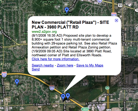
Petition under review at 3980 Platt Road.
City of Ann Arbor | Google Maps
From time to time on the agenda of the City of Ann Arbor, Pittsfield Township, Scio Township or Ann Arbor Township you will see annexation requests, which will change municipal boundaries as a result.
School district maps
A third very useful set of county wide maps are boundaries of school districts and townships, seen here combined on one map.
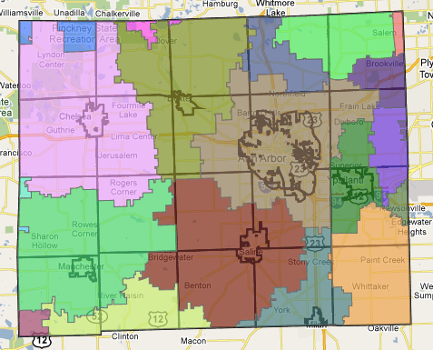
School districts and township boundaries.
City of Ann Arbor, Washtenaw County GIS
Township islands within the city of Ann Arbor
The irregular boundary of Ann Arbor creates township islands, parcels which have not been annexed to the City in the course of its growth.
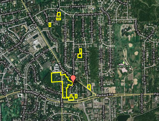
Islands of Pittsfield Township are completely surrounded by the City of Ann Arbor on streets like Shady Lane, Stone School Road, and Joseph Street.
City of Ann Arbor AAGIS
What it means for maps to be free
When these maps were originally released, they had a copyright notice on them which restricted them to internal use; that copyright was amended. The school district map detail page says:
"This feature dataclass was created with the intentions of displaying all of the school districts who's boundaries are located within Washtenaw County. The boundaries were created by dissolving the current Washtenaw County parcels layer by the school district field. In order to maintain the attributes of the old school districts file, we then lined up the boundaries from the old school districts map with the dissolved layer. After the boundaries were lined up, topology was created in order to verify that there were no topological errors within the feature dataclass."
Map-making can be hard work; there are a lot of details to get right.
Edward Vielmetti looks at maps for AnnArbor.com. Reach him at 734-330-2465
Comments
KJMClark
Sat, Feb 20, 2010 : 9:49 a.m.
Yeah, so who dropped the ball on those annexations? As of January 1st 2008, we should have started annexation proceedings on those properties. Those should be done deals by now. That's a good amount of revenue the city is throwing away each year.
Nerak
Sat, Feb 20, 2010 : 8:27 a.m.
This is great! Interestingly, however, what does it say about our educational system when the AAPS disclaimer has a grammatical error? (It should be "whose," not "who's," unless EV just typed it incorrectly.)
clan
Sat, Feb 20, 2010 : 2:03 a.m.
Smooth play Ed
Joseph Edwards
Sat, Feb 20, 2010 : 12:18 a.m.
Has the city ever calculated the potential property tax revenue it would collect if the islands were incorporated?
pvitaly
Fri, Feb 19, 2010 : 4:02 p.m.
Wooohoo for GIS! Let's see some trending maps. How about property tax values from 1990 to 2010 :)
topher
Fri, Feb 19, 2010 : 3:59 p.m.
I'm noticing that several of these townships pockets are fairly affluent areas of town. There also seems to be pockets with in pockets. Ha ha, I'd be pretty mad if I looked at this and discovered all my neighbors were in a township while I was paying city taxes.
Babonx
Fri, Feb 19, 2010 : 2:18 p.m.
I'm curious to know how that township islands occurred in the first place and why they aren't just part of A2. It would seem that it's not advantageous for the townships to hold onto these little bits and pieces. Further, who handles the policing and garbage collection... Ann Arbor or the township it belongs to?
sellers
Fri, Feb 19, 2010 : 1:23 p.m.
This is wild crazy-good stuff!
dconkey
Fri, Feb 19, 2010 : 12:54 p.m.
Very interesting maps. Everyone who uses a cell phone had better print out the first and carry it with them when they drive so they know where and where not they can use the phones if A2 passes the anti-phone bill.
Belgium
Fri, Feb 19, 2010 : 12:24 p.m.
Excellent info Ed. Thanks. Jonathan
John of Saline
Fri, Feb 19, 2010 : 10:53 a.m.
That one yellow spot (township island) across Eisenhower from Briarwood is a single house, I believe, that's been abandoned for years. I've watched it slowly deteriorate for over half a decade. Weird.