
Planning a trip or driving around town? A look at I-94, US-23, M-14 and local traffic real time maps
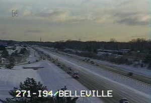
Michigan Department of Transporation traffic cameras watch over traffic on westbound I-94 near Belleville.
MDOT
Here's some maps that will help you get here — real time traffic status maps from Traffic.com, the Michigan Department of Transportation, Google, Yahoo and Microsoft's Bing that all try to provide a current status of how traffic is flowing.
Each service provides a slightly different view of the traffic network, so here are links and some screen captures to help you pick a few to bookmark.
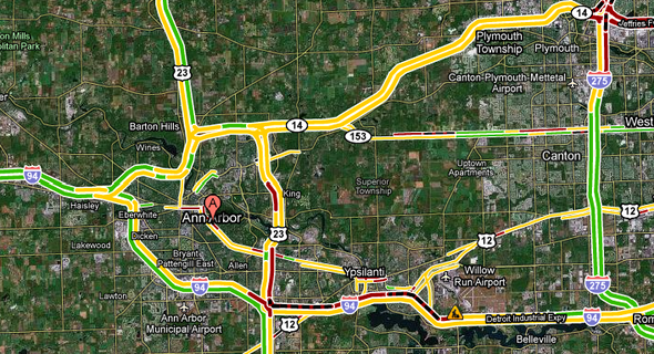
Traffic.com
NAVTEQ and Traffic.com provide traffic conditions for major roads in the area. They are distinctive among online traffic planning tools in offering drive time predictions, segment by segment. Traffic.com will let you set alerts so you receive an email when incidents happen. For real-time traffic updates on the go, call them at 866 MY-TRAFC.
NAVTEQ provides traffic information to a number of traffic sites; you'll see their copyright in many places where traffic information is to be found. The company was purchased by Nokia in 2008 for $8.1 billion. At the time, they covered road networks in 73 different countries, providing both real time data and travel directions. NAVTEQ's latest acquisition, Trapster, tracks speed traps and road hazards.
Traffic maps from traffic.com (powered by NAVTEQ) also include drive time predictions.
Traffic.com
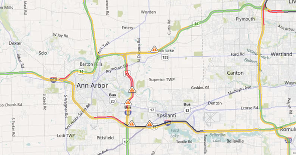
Michigan Department of Transportation (MDOT) map
Michigan Department of Transportation
The MDOT interactive drive map incorporates data from sensors and highway cameras around the Detroit area, including Wayne, Oakland and Macomb counties, but not Washtenaw County. Video cameras are set up at strategic spots along the network and speeds are measured directly on the road. Incident reports of accidents and construction are updated throughout the day, and there are markers for upcoming construction.
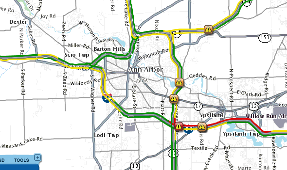
Yahoo Maps
Yahoo Maps.
Yahoo's traffic map provides reporting on county roads, including Dexter-Pinckney, Baker, Wagner and Ann Arbor-Saline roads.
Yahoo maps are powered by TrafficCast, which notes that it "provides real-time road speed information derived from GPS tracking data, public sensors and reports of accidents, road works and weather." The Yahoo traffic map centered on Ann Arbor shows reporting for roads that other systems don't generally cover, with overall better reporting on major county roads.
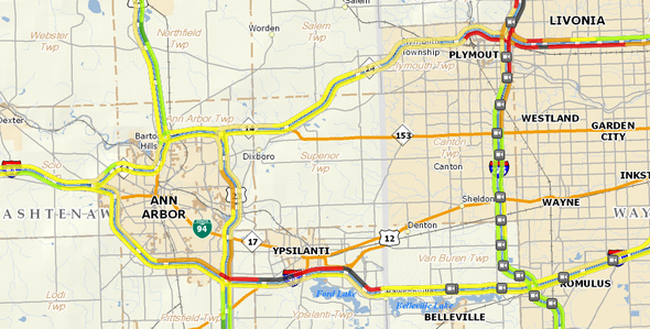
Google Maps
Google traffic information is overlaid on top of their familiar road maps.
The Google traffic map for Ann Arbor is notable for both its real time traffic and its predictive traffic; if you want to plan ahead to see what times of day major roads are likely to be full of cars, it's a good bet. Google's traffic mapping is also available on your mobile phone as Google Maps for Mobile.
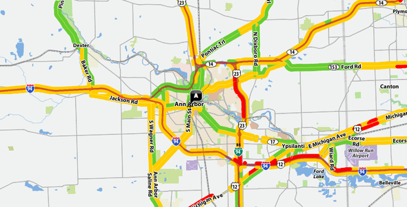
Bing.com from Microsoft
The morning's map from Bing shows slow traffic and several accident reports.
Bing.com, Microsoft
The Bing.com traffic map for Ann Arbor from Microsoft is also powered by NAVTEQ. Microsoft is playing catch-up with Bing, its entry into the search engine wars; the traffic maps it provides are competent and are distinguished by clear integration with traffic incident reporting.
The future of traffic online real time mapping
The Federal Highway Administration has established a requirement for the states to implement real-time information systems for Interstate highway systems, with the systems to be put into place no later than November 8, 2014.
SUMMARY: Section 1201 of the Safe, Accountable, Flexible, Efficient Transportation Equity Act: A Legacy for Users (SAFETEA-LU) requires the Secretary of Transportation (Secretary) to establish a Real-Time System Management Information Program that provides, in all States, the capability to monitor, in real-time, the traffic and travel conditions of the major highways of the United States and to share these data with State and local governments and with the traveling public. This rule establishes minimum parameters and requirements for States to make available and share traffic and travel conditions information via real-time information programs.
More details are available from the Federal Highway Administration's Real-Time Traveler Information Program. The rules, and over 100 public comments that help shaped them, are available from regulations.gov.
Edward Vielmetti navigates for AnnArbor.com. Contact him at edwardvielmetti@annarbor.com.
Comments
Babonx
Fri, Apr 2, 2010 : 10:43 a.m.
Ed, you always put together the most interesting groups of links.