Federal data catalog at Data.GOV: Farmers markets, failed banks, and peculiar Arkansas earthquakes
The Federal government collects an enormous amount of data about what goes on in the world. Agencies collect this data in the course of law enforcement, program spending, health and safety management and a thousand other reasons.
Data.GOV is a single point of contact to look for freely available, published data sets, maps, and statistical information that can be downloaded directly. It coordinates and consolidates, but does not replace, individual publishing efforts by each agency. The site claims that 308,666 different data sets are online, representing the work of 258 federal agencies. Here is at best a brief sample of the information, with a look not only at what's there but also how it might be put to use.
Farmers market locations from the US Department of Agriculture
Data set 4383 is the Farmers Market Geographic Data collection. A spreadsheet contains the name, address, zip code, latitude, and longitude of farmers markets across the country. The data, from the Department of Agriculture's Agricultual Marketing Service, is current to the year 2010, and there are about 6250 locations identified, including 318 in Michigan.
A collection like this can be expected to have a certain amount of imperfections, and some simple searches in Excel identify records that really don't belong. 13 test records are in the data, with market names like "Yue Test" or zip codes and cities that don't match. 67 of the 318 Michigan markets are missing latitude and longitude information, of more than 1500 - a quarter of the data set - that lack this key attribute.
Fortunately, the USDA is not the only source of farm market information. The Ann Arbor based Real Time Farms, which I credited for my 2010 summer market preview, has not only market location information but also photographs of vendors and their produce, contact information for market managers, and maps of local farms. I'm certain that there's at least one market that the USDA found that Real Time Farms hasn't located, but given the choice between a page full of photos and a single line in a database the choice is easy.
Failed banks from the FDIC

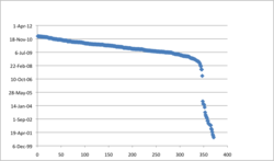
Bank failures accelerated sharply in 2008 after years of relative stability, based on FDIC reporting of bank takeovers.
Edward Vielmetti | AnnArbor.com
Data set 1374 is the FDIC failed bank list, updated weekly with information about failed banks. The report simply contains the name of the bank, its city and state, and the name of the institution that acquired the bank. It's one of the most popular data sets in the entire collection.
Given this raw data, it's possible to relatively easily identify the turning point in the US financial crisis. The chart below plots failure dates in sequence; it shows all too clearly a sharp transition from a world where bank failures are unusual to a world where on a single day in November 2008 as many banks failed as did in all of 2004 through 2007.
Worldwide earthquakes, last 7 days
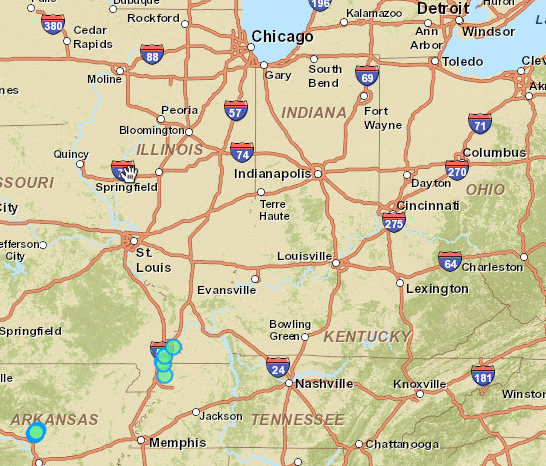
Data set 34 is the Worldwide M1+ Earthquakes, Past 7 Days data set, updated continuously by the US Geological Survey. Every quake is available in a spreadsheet format as well as KML format files which can be loaded into a world browser like Google Earth. If the earth starts to shake, you can generally identify whether it was a passing truck or an earthquake within a few minutes by consulting this data.

Courtesy US Geological Survey
The closest recent earthquakes to the Ann Arbor area are a distance away, much too far away to be felt. A series of small quakes in southeastern Missouri, about 10 hours south and west of Ann Arbor, is associated with the New Madrid fault. A series of peculiar earthquakes in Arkansas is less easily explained and may be man-made. Here's the USGS on the Arkansas swarm, from an analysis of a recent magnitude 4.1 quake near Greenbrier, Arkansas, about 14 hours away by car from Ann Arbor:
This earthquake is part of a swarm of earthquakes that began on Tuesday February 15, 2011 and is continuing. This area is slightly south of and most likely related to similar activity (known as the Guy earthquake swarm) of hundreds of small earthquakes near Guy, Arkansas from August 2010 to present. Central Arkansas has a history of earthquake activity with a swarm of thousands of earthquakes smaller than magnitude 4.5 to 4.7 in the early 1980s and another swarm in 2001 (known as the Enola earthquake swarms). The Center for Earthquake Research and Information (CERI) at the University of Memphis and the Arkansas Geological Survey (AGS) have deployed a local seismic array in the Greenbrier-Enola, Arkansas, area to augment regional seismic stations to carefully monitor this situation. USGS scientists have been working with their AGS and CERI colleagues. The CERI and AGS array and personnel are the best source of the most current information about the new earthquake swarm. The AGS and CERI are investigating whether the earthquakes occur naturally or are related to human activities.
The human activities in question are injection of wastes from oil and gas drilling into wells; Oil and Gas Online reports that several companies that were operating those injection wells had stopped, and a moratorium put in place in December 2010 now prohibits new disposal wells from being dug.
Edward Vielmetti collects public records for AnnArbor.com.

