
National Weather Service map shows path Dexter tornado took
This map shows the path taken by the tornado that struck the Dexter area Thursday evening.
National Weather Service map
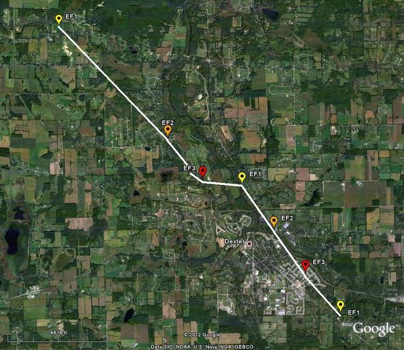
The National Weather Service has posted a map and description of the path taken by the tornado that struck the Dexter area Thursday, damaging at least 100 homes and destroying 10.
The tornado first touched down at 5:17 p.m. northeast of North Territorial and Dexter Townhall roads. At that point, it was what the weather service classifies as an EF-1 tornado, with winds of about 100 mph. It uprooted trees and caused minor roof damage, the weather service said.
The weather service rates tornadoes on the Enhanced Fujita Scale from EF-0 to EF-5. An EF-1 storm has winds of 86 to 110 mph. The weather service said Friday that the Dexter tornado was an EF-3 storm at its strongest point and covered a path 7.2 miles long and up to 800 feet wide.
The tornado then hit Horseshoe Bend Drive in the Carriage Hills subdivision with EF-2 winds of 120 mph, causing structural damage to the outside of homes. It moved southeast along Dexter-Pinckney Road and intensified to an EF-3 storm at 5:31 p.m. The storm, by now packing winds of 135 to 140 mph, destroyed a home northwest of Dexter.
The tornado then took a left turn and moved along Huron River Drive, weakening to an F2. By 5:49 p.m. when the storm struck the Huron Farms subdivision, the hardest-hit neighborhood, winds had climbed back to EF-3 strength of 135 to 140 mph, the weather service said.
As the storm moved southeast, it began to weaken and lifted at 5:52 p.m. near Zeeb and Dexter Ann Arbor roads, the weather service said.
The weather service also has posted graphics showing other information about the storm, as well as photos and a map of the path of the tornado that hit Lapeer County Thursday.
A map posted earlier shows reports from storm spotters of tornadoes, funnel cloud sightings and hail around southeast Michigan Thursday.
Contact Cindy Heflin at 734-623-2572, or cindyheflin@annarbor.com or follow her on Twitter.
Comments
Martin Craig
Mon, Mar 19, 2012 : 4:13 p.m.
This map is misleading as there were multiple cyclones, not just one. A map of this sort is sensitive and needs verification and posted metadata. Posting this map was an act of negligence not only on the part of the mapmaker but also on the part of the person who posted it.
Key
Mon, Mar 19, 2012 : 6:11 p.m.
Negligence seems a bit strong.
John
Mon, Mar 19, 2012 : 11:10 a.m.
How accurate is that? The path goes right over houses which are still standing un-harmed in Huron Farms, and a block or two away from some of the most damaged, i.e. the house at the corner of York and Meadow View.
shutthefrtdoor
Mon, Mar 19, 2012 : 2:54 p.m.
Yes agree curious...look at the sub-division. There are houses demolished between homes that are still standing.
justcurious
Mon, Mar 19, 2012 : 1:50 p.m.
If you look at some of the videos, it shows the tornado forming and on the ground then "lifting" up again. It seemed to "hop" over areas and then touch down again. Many houses between the Dexter Mill barn that was demolished and the Huron Farms sub escaped any damage. It must have "lifted" at those points.
Ann English
Mon, Mar 19, 2012 : 12:09 a.m.
I remember a high school earth science textbook teaching that tornado paths are twisting and unpredictable. My earth science teacher taught us that tornadoes move in a northeast direction. But this tornado didn't move on a northeast path, and the path wasn't twisting and unpredictable.
microtini
Mon, Mar 19, 2012 : 2:53 a.m.
You must've gone to school in South Lyon.
justcurious
Mon, Mar 19, 2012 : 2:33 a.m.
It seems like it lifted at times and did change course several times. There not much visible damage between just east of the car wash and the subdivision. It must have "hopped".
Kevin McNulty
Mon, Mar 19, 2012 : 12:04 a.m.
Hats off to the DAFD, all the fire departments that responded and the law enforcement agencies helping still with traffic control and HVA. Great job done by all.
Korach
Sun, Mar 18, 2012 : 11:37 p.m.
The turn to the east was south of indicated. We walked through the woods a quarter mile north of the Westridge subdivision and you could clearly see where it touched down just north of the power lines until it reached river. Following the downed trees it pretty much stayed close the river before coming down again near 2nd street. The planned path of the B2B trail is covered with downed trees.
justcurious
Mon, Mar 19, 2012 : 2:34 a.m.
Even closer to my house then.
ChelseaGirl
Sun, Mar 18, 2012 : 9:55 p.m.
We rode out the storm/tornado in the Monument Park Bldg in downtown Dexter. My heart goes out to all of the residents and their families.
justcurious
Sun, Mar 18, 2012 : 8:29 p.m.
We are 1/4 to 1/2 mile s. of where it turned east and intensified to an F3. I was home with 3 dogs and 2 cats and no basement. Pure luck that it did'nt head due south. Sky to. North was wall of black. I was photographing and videoing enormously loudspeakers to south with black wispey clouds being sucked north. The at 5:32 pm the rain. and hail started. Incredible wind and noise. The whole thing lasted maybe 40 minutes. We still don't have Charter internet or TV.
justcurious
Mon, Mar 19, 2012 : 4:49 p.m.
shutthefrtdoor, I like your handle too. Seriously. I can't believe clouds turned into loudspeakers. I will check that site out. Too bad I type while looking at my fingers instead of the screen. Typing on the cellphone was even worse. How on earth do people text? lol
shutthefrtdoor
Mon, Mar 19, 2012 : 2:52 p.m.
Too funny...did you know they have websites dedicated to "auto-spell" boo boo's? Pretty hilarious if you need a laugh!
justcurious
Sun, Mar 18, 2012 : 8:34 p.m.
Can't type on phone. Not Loudspeakers, clouds!!! Hate automati. Spellchecker.
greg
Sun, Mar 18, 2012 : 3:35 p.m.
Looks like the original track had it going right though downtown Dexter. Sorry for those that were effected, but that was a very near miss for the city.
mentalNomad
Sun, Mar 18, 2012 : 1:15 a.m.
Could you do an overlay of the tornado path map with street names? Or create a Google map with the entire path of the tornado?