
March heat wave spawned rare Dexter tornado
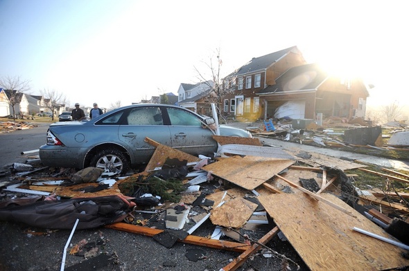
Residents survey the damage on Noble Street in the Huron Farms subdivision in the Dexter area Thursday.
Angela Cesere | AnnArbor.com
The tornadoes that struck Dexter and other parts of Michigan Thursday were an extremely rare breed of storm.
Southeast Michigan has had only eight tornadoes in March in the last 61 years, said National Weather Service meteorologist Cory Behnke. This week there have been four, including three Thursday.
The culprit? It’s at least partly the fault of the record warmth we’ve been enjoying for the past few days. Warmer air holds more humidity than cool air and it’s humidity that is required for the instability that creates severe thunderstorms and tornadoes, Behnke said.
The National Weather Service has a team of storm investigators in the Dexter area today assessing the strength and path of the storm. The team will look at damage to determine the relative strength of the winds from the storm.
The investigators will then give the storm a rating based on the enhanced Fujita scale, which ranks tornadoes on a 0 to 5 scale. A tornado with a 0 rating has winds from 65 to 85 miles per hour. A storm with a 5 rating has winds over 200 mph.
Media reports indicated the storm may have been an EF-3, a severe storm with winds between 158 and 206 mph, but Behnke said it’s too early to make that determination. Tornadoes also struck Lapeer County and the Ida area in Monroe County Thursday.
A National Weather Service meteorologist Thursday night said the storm was estimated to have been on the ground for 25 to 30 minutes. That’s a long time to wreak havoc with buildings and trees, and the damage was devastating. The storm damaged at more than 100 homes, including 10 that were destroyed; uprooted trees and felled limbs; and knocked out power to much of the Dexter area.
The storm also dumped nearly 2 inches of water on the area. University of Michigan weather observer Dennis Kahlbaum recorded 1.06 inches of rain at his North Campus station, but he said 1.8 inches were recorded on the west side of Ann Arbor. It caused flooding in Ann Arbor that forced residents out of an apartment complex and stranded dozens of people in their cars, forcing firefighters to rescue them.
Kahlbaum was part of the Skywarn network of spotters tracking the storm Thursday. He said the storm was originally moving to the east but then took a strong turn to the right, which usually indicates a strong intensification. The storm then moved through southeastern Washtenaw County and into Monroe County.
Kahlbaum said the high temperature for the day was 75 degrees at his North Campus weather station Thursday. That was one degree shy of the record 76 set in 1990. Detroit tied the record for March 15 with a high temperature of 77 degrees, Behnke said.
Southeast Michigan recorded dew points _ the temperature at which the air becomes saturated _ in the low 60s Thursday, Behnke said. That compares to normal dew points in the low 30s. Dew points that high are extremely rare for March, he said.
“I can’t tell you how many times it has occurred in the past in southeastern Michigan, but it hasn’t happened often I can tell you that.”
It's not clear whether the area is in for more severe weather this month. The next chance of thunderstorms is Saturday night.
"It’s hard to say if Ann Arbor will get more sevee weather, but if this weather pattern holds the potential is certainly there," said AccuWeather meteorologist Tom Kines.
Comments
motownsound
Sat, Mar 17, 2012 : 9:06 a.m.
Dear Al Gore- There's no such thing as global warming.
Roger Rayle
Fri, Mar 16, 2012 : 6:52 p.m.
Here's a link to screenshots of a Google Earth mashup that shows the approximate tracks of all known Michigan tornadoes 1950-2008: https://picasaweb.google.com/114160427288330834686/MITornadoTracks19502008 (derived from http://www.srh.noaa.gov/gis/kml/TIMS/state_tor.kmz) I normalized the tracks to the geographic center of all tornadoes to show that not all tornadoes travel east-northeast. Fortunately for us, most Michigan tornadoes are category 0 or 1. I'm glad people survived this rare event... even more rare for March. I'll post some links to summary data about Michigan tornadoes later. (... more examples of what you can do with "Open, Linked Data")