
Corridor plan for State Street wins approval from Ann Arbor City Council
The Ann Arbor City Council voted unanimously Monday night to adopt the new South State Street Corridor Plan, a city planning document more than a year in the making.
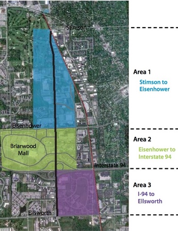
The plan, which includes land use and transportation recommendations for the 2.15-mile stretch of State Street from Stimson to Ellsworth, is now an official part of the city's master plan.
City Planner Jeff Kahan said the corridor plan was developed in response to significant changes that have taken place along South State Street over the past two decades.
City of Ann Arbor
City of Ann Arbor
"Because of South State Street's concentration of high-activity uses, proximity to downtown and the highway, and lack of conflicting land uses, the corridor offers a unique opportunity to address community priorities such as transportation infrastructure, land-use patterns, sustainability, and economic development," the new plan states.
The plan states that corridor stakeholders — including residents, business owners, the University of Michigan, Ann Arbor Transportation Authority, Pittsfield Township, and the city of Ann Arbor — are unified in the desire to revitalize the corridor and develop a welcoming gateway that reflects the character of Ann Arbor.
The Planning Commission kicked off the public engagement process for the planning study in spring 2012. That included interviews with 50-plus stakeholders and two public meetings.
The public identified traffic congestion, aesthetic concerns, inadequate non-motorized facilities, poor wayfinding and a desire for more vital land uses as issues to be addressed, Kahan said.
The resulting corridor plan contains goals and recommended actions that tie directly to the city's sustainability framework, Kahan said.
Previous coverage:
- 41-page draft plan outlines new vision for Ann Arbor's South State Street corridor
- South State Street Corridor Plan: A new vision for Ann Arbor's critical gateway
Ryan J. Stanton covers government and politics for AnnArbor.com. Reach him at ryanstanton@annarbor.com or 734-623-2529. You also can follow him on Twitter or subscribe to AnnArbor.com's email newsletters.
Comments
Mick52
Tue, Jul 16, 2013 : 5:04 p.m.
IMHO A2 does not need any enhancement other than getting the roads in good condition. The state of the roadways in Ann Arbor is embarrassing. I drive a little further every time I go to the city so that I can drive on a newly improved road because the shorter route is in such bad shape.
NUXI
Tue, Jul 16, 2013 : 3:42 p.m.
I'm glad they are thinking of maybe possibly fixing the sidewalk gaps around wolverine tower and up at Stimson. When can they come fix Birch Hollow Dr? They should stop their sidewalk repair program for like 2 years and spend that money closing these gaps and replacing sidewalk that is truely substandard. I've been scratching my head at the reason some seemingly fine blocks of sidewalk are marked for repair.
NUXI
Tue, Jul 16, 2013 : 6:57 p.m.
And by birch hollow dr I really meant to say stone school road.
Brad
Tue, Jul 16, 2013 : 4 p.m.
Plus have you seen this "cutting/grinding" thing they're doing on the sidewalk joints? Looks not that great.
Veracity
Tue, Jul 16, 2013 : 3:11 p.m.
With so little interest in visiting places along the northern stretch of South State Street, a bus can travel all the way from Stimson to Eisenhower Parkway without stopping if the bus catches a green light: a mile-and-a-half in two minutes flat! (And vice versa)
Veracity
Tue, Jul 16, 2013 : 2:58 p.m.
Actually, the real purpose of establishing a corridor plan is to progress to an "South State Street Corridor Authority" (SSSCA). The SSSCA, like the DDA and the AATA, will have taxing rights which would, for example, allow milllages. The tax payer dollars collected will then be used to provide inducements to developers, such as providing Brownfield remediation or direct grants of money. Deferrals of TIF payments for a variable number of years can also be arranged to the benefit of each project's developer/owner. The intention of a "corridor authority" is to privatize tax payer dollars while socializing debt and investment losses, IMHO.
Basic Bob
Tue, Jul 16, 2013 : 4:12 p.m.
this will connect to the state road cia already approved in pittsfield - a plan to divert 32 million dollars to a 4 lane boulevard connecting costco to saline high school
arborani
Tue, Jul 16, 2013 : 3:21 p.m.
Scary.
GratefulReb
Tue, Jul 16, 2013 : 2:56 p.m.
Does this mean State Street will get repaired? The condition of this road is truly awful.
L'chaim
Tue, Jul 16, 2013 : 2:30 p.m.
just build a really, REALLY big Wal-Mart. very A2.
JRW
Tue, Jul 16, 2013 : 1:06 p.m.
Take out all public art projects from this proposal. The city just doesn't get it.
Veracity
Tue, Jul 16, 2013 : 3:04 p.m.
MRunner73 - Have you seen the beautiful lawn and trees in front of the Edwards Brothers Publishing facility? Planning Commissioners and some City Council members are licking their chops at the prospects of building a 15-story building on that land.
MRunner73
Tue, Jul 16, 2013 : 1:29 p.m.
Agreed, how about the city just has manicured lawns and shrubs. Keep the street clean, add more lanes for traffic. All of that would be appealing to visitor and locals.
Nicholas Urfe
Tue, Jul 16, 2013 : 1:04 p.m.
I see no mentions of pedestrians or bicyclists in this summary. Maybe those are in the plan? With all of the offices in the area, and residences, some people do prefer not to drive to lunch.
foobar417
Tue, Jul 16, 2013 : 4:10 p.m.
Page 35 has a nice map.
foobar417
Tue, Jul 16, 2013 : 3:35 p.m.
There are some concrete non-motorized recommendations in the plan, but maybe not the summary. They key one (in my mind) is to formally state that the goal would be to connect the AA Greenway (whenever it is finally built) from Stimson (which is where previous plans always had it ending) along the railroad out to Pittsfield and the growing network of non-motorized trails out there.
Usual Suspect
Tue, Jul 16, 2013 : 12:26 p.m.
Some of it makes sense. I suppose that fixing the traffic patterns around at Briarwood is kind of a "better 30 years too late than never" situation. I'm not impressed or surprised to see the by the public art garbage in there, through. Some people just don't know when to stop, not understand the meaning of "no."
Lolly
Tue, Jul 16, 2013 : 12:11 p.m.
RUKiddingMe, we must not be reading the same text. I see many concrete recommendations and action steps. This looks very good to me--thoughtful and comprehensive. And I can't wait for some of the easily-done improvements to the streetscape.
Mick52
Tue, Jul 16, 2013 : 5:02 p.m.
I'm with RUK, Lolly, I don't see any details either, just vague terms, nothing that explains exactly what they are going to do.
Halter
Tue, Jul 16, 2013 : 11:11 a.m.
Plans are all well and good -- don't see much happening in this area though. Visitors to the area see a mixed-use hard-to-access because of traffic intersection-filled neighborhood...people who live there in the Hidden Valley complex are generally transitory and move somewhere else when they can afford it...and while it doesn't look bad, it doesn't scream "come work/live here"....But still, the plans are good -- will see what happens (from someone who owns a business in this corridor)
Basic Bob
Tue, Jul 16, 2013 : 10:38 a.m.
How about putting the interchange crossing behind Briarwood, connecting to the Lohr Road asphalt path?
RUKiddingMe
Tue, Jul 16, 2013 : 10:36 a.m.
My favorite part of the plan is that there's a spell-checkable error on the very first textual body page: "The South State Street Corridor Plan contained herin" Other than that, I skimmed through the first 14 pages and see a lot of very vague suggestions for studies and "work with X to come up with plan for X." As in not many real concrete plan items. Can anyone spend more time on this to see if it can't be distilled down to "we should have vibrant culture and consider diverse and affordable housing and saafe, efficient transportation?" Is this the typical type of beginnings of brainstorming for this document at this stage and after a year of work? I also see lots of references to previous studies in 2007, 2009, and 2010. Are we just rehashing and redesigning this year-long planning document every year or so?