
Ann Arbor prepared to remove 452 buildings from new FEMA floodplain maps
Ann Arbor officials will conclude a years-long process by April 2 when City Council takes the formal step of approving new federal floodplain maps for the city.
The Flood Insurance Rate Maps — in the works since planning meetings began in 2004 — are the well-researched updates to 1992 maps that were estimated by the Federal Emergency Management Agency.
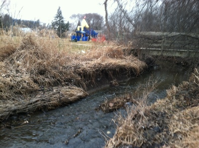
The Swift Run Drain in Sylvan Park on the city's east side.
Keegan Gardner | For AnnArbor.com
Several hundred buildings are moving out of the area designated at risk for flooding, while dozens are entering it as the boundaries are redrawn.
“There’s a huge reduction in the number of buildings in the floodplain,” said Jerry Hancock, the city’s stormwater and floodplains programs coordinator.
Across the city, 452 properties are moving out of a floodplain, while 88 will move into one. That represents a 43 percent reduction.
Buildings in a floodplain require flood insurance, Hancock said. The changes also could affect what kind of development could take place on a property.
With flood insurance averaging an estimated $2,000 per year, the difference could be notable for a property owner.
The new maps go into effect on April 3, and by ordinance City Council has to approve them before that time.
City staff has notified all of the building owners involved in the change, Hancock said. The bulk of the properties moving out of the floodplain are in either the area of the Swift Run drain on the city’s far east side or the Allen Creek area from Hill Street to East Stadium.
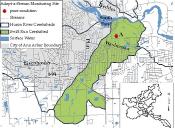
Swift Run drain area.
City of Ann Arbor.
FEMA worked out preliminary maps in 2007, and they resemble the final maps, Hancock said.
People who’ve planned to develop in the city have been watching for the final versions for some time, Hancock added.
“With every developer who’s come in since 2004, I’ve had to say the boundaries could be changing,” he said.
Comments
greg
Mon, Feb 20, 2012 : 3:21 a.m.
Can someone please explain what the map image is that is included with this article? Is it the drain area or the flood plain? It's not the same as the one shown when I go to the Ann Arbor flood plain map.
Vince Caruso
Sun, Feb 19, 2012 : 1:14 a.m.
These maps were long in coming but it would have been nice if the city and county agreed to spend a little money when the consultant drawing the maps suggested we include parts of the Allen's Creek technically not required to be included. The city and county refused. The consultant also said the models are very limited because so little data is currently available to calibrate them with. It would also been nice if the maps were based on data other than asking folks to point on the buildings were the flood waters were just after the 1968 flood. There is some talk of collecting new data to provide support to the models used to draw the maps which is good if it happens. The original plan for the Homeless Shelter ($1M) was scraped because a group of citizens showed it would be in the REAL floodway not the one on the old map; long since illegal to build residential in the floodway. It was moved up the hill and violated many city zoning regs. that were promised to be fully complied with at the start of the planning and cost much more then it should to build. With Global Warming causing more intense rains and poorly backed floodplain maps we are not protecting unsuspecting residents from major flooding as we should and could.
toothless wonder
Sat, Feb 18, 2012 : 5:58 p.m.
To view the floodplain map :( then it goes to - PLEASE INSTALL MICROSOFT SILVERFISH) I don't want to infest my computer.
leaguebus
Sat, Feb 18, 2012 : 5:26 p.m.
For all the government conspiracy theorists, a flood is not just water above ground, the first things that flood are basements. $2000 a year is cheap if someone needs to replace a furnace and air conditioner once in a while.
ffej440
Sat, Feb 18, 2012 : 7:22 p.m.
You Tube- search Keith Haley
ffej440
Sat, Feb 18, 2012 : 7:19 p.m.
For starters most of your A/C system lives OUTSIDE your house, the evaporator is inside but will not be damaged by water. Damage to a furnace by water is usually limited to blower motors that cost way less than $2,000. Once FEMA puts you in the zone, you have NO choice but to pay. I might wreck my car but I'm not required to have full coverage. It may feel good to always have blind trust in government but if you look at these "conspiracy theorists" you may find the truth. Check out Keith Haley from Michigans story regarding his home and FEMA flood insurance.
ffej440
Sat, Feb 18, 2012 : 5:14 p.m.
Another Federal scam. We all know flooding in the US always happens in the same places. In order to keep the insurance down to $2,000 per year the Feds have chosen places that are not very prone to flood to include in the required insurance areas. So the folks in Michigan get to subsidise the folks in New Orleans so they can live in a REAL flood plain for only $2,000.
cibachrome
Sat, Feb 18, 2012 : 4:30 p.m.
So is the Ark being moved to the floodplain?
jcj
Sat, Feb 18, 2012 : 2:58 p.m.
It makes you wonder do they EVER read these article back to themselves?
nvragain
Sat, Feb 18, 2012 : 3:10 p.m.
Editing cost money they would rather spend paying someone to remove comments. We are spared inflammatory comments at the cost of quality journalism. A business model for success!
David Frye
Sat, Feb 18, 2012 : 2:13 p.m.
Lenders require flood insurance. You can't get a mortgage on a house in a floodplain without it. If you pay cash (or pay off your mortgage), you can drop the flood insurance -- not necessarily a wise thing to do, but the insurance is expensive (about $2000/yr) and floods are relatively rare, so people take the risk. That is why some people who have been living in their houses for decades end up losing everything in a flood.
smokeblwr
Sat, Feb 18, 2012 : 1:08 p.m.
So....how are they going to move all these buildings? On big trucks with cranes? How much is THIS going to cost the taxpayers?
alterego
Sat, Feb 18, 2012 : 6:47 p.m.
Laughing hysterically.
jcj
Sat, Feb 18, 2012 : 2:57 p.m.
I'm with you on this one smokeblwr. Very poorly written!
dexterreader
Sat, Feb 18, 2012 : 2:32 p.m.
Ha ha!! I thought the exact same thing when I first read the headlines!! Kind of curious what the criteria is for redrawing the boundaries though.
Rugeirn Drienborough
Sat, Feb 18, 2012 : 2:26 p.m.
@DDOT1962: "At least pretend like you've" got a sense of humor. The pretense won't fool anybody, but the effort will be good for you.
Rugeirn Drienborough
Sat, Feb 18, 2012 : 2:23 p.m.
Well, the Egyptians used lots and lots of people and rollers to move very large, heavy objects, so perhaps we'll do the same. It should do wonders for the short-term unemployment rate, and might increase tourism as well.
dina
Sat, Feb 18, 2012 : 1:54 p.m.
hilarious! move "452 properties out of the floodplain" --that's HUGE! may need the cosco helicopters to get this job done! that accomplished, how will the "88 move into one"? and by properties, do they mean land and all, or just the buildings? if it's land too, it's gonna be a big mess. properties sprinkled all over creation! my, my, my!
Tony Livingston
Sat, Feb 18, 2012 : 1:43 p.m.
Yes. The way this is written makes it sound like buildings are going to be moved.
DDOT1962
Sat, Feb 18, 2012 : 1:25 p.m.
At least pretend like you've read the article.
A2comments
Sat, Feb 18, 2012 : 12:55 p.m.
"Buildings in a floodplain require flood insurance, Hancock said." Really? Why then do we watch flood disasters on TV and hear about all those who lost everything due to having no flood insurance? Quick research shows when flood insurance is required. <a href="http://www.floodsmart.gov/floodsmart/pages/about/when_insurance_is_required.jsp" rel='nofollow'>www.floodsmart.gov/floodsmart/pages/about/when_insurance_is_required.jsp</a>. I did not analyze where in A2 this would apply.
johnnya2
Mon, Feb 20, 2012 : 5:41 a.m.
1. Renters 2. People who own their properties outright 3. Non federally regulated mortgages 4. Flooding happens in NON floodplain areas as well Insurance also only covers the DEPRECIATED value of an item. Your 5 year old television does not get replaced, You get the value at the time of your loss. Your car is whatever Kelly Blue Book was at the time of loss. Even though you may not be able to get one at that price in an area ravaged by flooding anyway. There are also losses on things that can not be replaced financially. Pictures of your family, pets, etc Maybe IN-DEPTH research might give you an education
Chip Reed
Sat, Feb 18, 2012 : 12:40 p.m.
@Paula, I think the city floodplain map has been swept away by the current (I didn't mean to plug the competition).
yohan
Sat, Feb 18, 2012 : 12:37 p.m.
"Buildings in a floodplain require flood insurance, Hancock said." What are the origins of this requirement? Lenders or or a government organization?