
After hitting 101 Saturday, temps Sunday and this week should hover in the 80s
There’s good news for those of you who’ve spent much of the past week sweating: Relief has arrived.
“The worst of the heat is definitely over for now,” said Alan Reppert, senior meteorologist with AccuWeather. “It looks like temperatures are going to remain pretty much in the lower- to mid-80s for the rest of the week.”
A screen shot of precipitation Saturday around Ann Arbor from the National Weather Service's website.
Recent thunderstorms have also helped counter a dry start to summer.
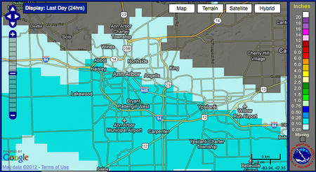
Portions of Washtenaw County received up to .14 inches of rain Saturday, according to the National Weather Service. Since the beginning of June, rainfall measured at the airport totaled 1.91 inches, two inches below the normal amount of 3.93 inches.
For the year, Reppert said, the area has received 11.65 inches of rain, compared to an average 15.69 inches to date in a typical year.
“If you look back all the way to January, we’re at 75 percent of normal, so it’s not too far below normal,” Reppert said.
Monday will bring a chance of shower or thunderstorm, but the rest of the week looks dry, he said.
Find up-to-date weather information and forecasts anytime on AnnArbor.com’s weather page.
Comments
jns131
Mon, Jul 9, 2012 : 4:35 p.m.
Some interesting trivia I learned over the weekend. The human body can sustain a temperature of 215 for 30 minutes. As for this heat wave? I think it is over. If I remember correctly, this heat lasted last year for 10 days when it went over 95 and then was great all summer long. We already had 10 days of 95 plus temps. I really hope it is over.
tdw
Mon, Jul 9, 2012 : 12:34 p.m.
I like how the lefties use a few hot seasons as proof of global warming but when we have really cold winters it means nothing. Republicans don't deny climate change they just don't believe it caused by man.The fact is that the climate has been changing for thousands of years, remember that thing called the ice age ? how did it end ? ( hint: it had to do with the climate )
Macabre Sunset
Mon, Jul 9, 2012 : 4:19 p.m.
The fact that this has become a Republican versus Democrat issue is the problem. At this point, it's hard to trust those who study the issue. The East Anglia people have become "Medieval Warming Period Deniers" and have threatened journals with banishment if editorial staffs publish anything to the contrary.
Griffin
Mon, Jul 9, 2012 : 2:25 p.m.
Global Warming is not the issue to tout, it is Global Climate Change overall. That includes extremes at both ends of the thermometer. Both extreme hot and cold can severely affect the environment. Really cold winters do mean something.
Tru2Blu76
Mon, Jul 9, 2012 : 4:48 a.m.
Quoting climatologist Jeff Masters: "The extraordinary heat wave of late June/early July 2012 toppled more Dust Bowl-era records on Friday, with three cities in Michigan hitting their hottest temperatures ever recorded. Lansing hit 103°, the hottest day in Michigan's capital city since record keeping began in 1863. Lansing has hit 102° four times, most recently on July 24, 1934. Muskegon, MI hit 99°, matching that city's record for all-time hottest temperature set on August 3, 1964. Records go back to 1896 in Muskegon, which has never hit 100°, due to the cooling effect of nearby Lake Michigan. Holland, MI hit 102° Friday..." Wow, the old Nose for News (aka, knowing what the public wants to know) sure is a dead horse in this town. The above climate data is sensational: yet it's not even mentioned in this "weather reporting" article. Suspicious, in fact, because diverting over to the comparatively mild drought data draws attention away from the more salient information. Terre Haute, IN. has a heat index of 129º Saturday: that's world record data. But nooo, we don't want to be telling of this because... maybe it's an inconvenient truth?? This brings an old expression to mind: Shape up or ship out. Jobs being so hard to come by, I'm sure that there are people who would jump at the chance to report the news to the people of Ann Arbor. Really, I'm disappointed and disgusted.
MRunner73
Mon, Jul 9, 2012 : 11:31 a.m.
Please check an article by an equally expert climatologist, Joe D'Aleo posted on the web site: Icecap.us. This heat rivals those of the early 1950s, with some 60 year cycles. As for Terre Haute's 129 Heat Index, it is in the heart of large corn fields and the broad leafed crop tends to transpire water vapor into the air. The highest HX are found in the Persian Gulf: Kuwait City comes to mind. Ann Arbor.com has done a good job of reporting the heat. I have not heard of any local fatalities. Perhaps some stats on heat exhaustion at local emergency rooms would help some.
nickcarraweigh
Sun, Jul 8, 2012 : 10:08 p.m.
Thank goodness the right wing has spent years teaching us global warming is only a myth, or I might be worried.
Tru2Blu76
Mon, Jul 9, 2012 : 7:41 a.m.
@Mike: Ah, the famous and long-lived UN Phobia is your guide. Well, it may or may not be true but the one thing you're dead wrong about is that we don't have a dictatorship. When one small group of rich guys can topple the entire national & world economies with just one of their little fraudulent scams and STILL not even be arrested: you can be 100% sure OUR system of laws has been successfully bought out by the crooks. Meanwhile, they use both political parties to create "dual threats" which keep the public busy fighting pointless ideological battles... exactly like you're doing. :-) The people pushing your Fear Button already own you. Good luck with your pointless ideological battles.
Mike
Mon, Jul 9, 2012 : 3:54 a.m.
Get your wallet out Nick. The UN is planning on pushing for a global tax on "global warming". China and Russia will most certainly tell the world to take a hike knowing full well that weather patterns repeat themselves and that we'll spend what's left of our county's wealth chasing this "problem". Obama will sign the treaty/theft of our future but luckily we're not a dictatorship and congress will veto it. There is also a global gun contolr intiative that will be coming up for vote. I'm sure you're not a gun owner, because the government will protect you from all of your worries. If you really thing all of the money in the entire United States can control the weather I have a bridge I'd like to sell you............
Macabre Sunset
Mon, Jul 9, 2012 : 1:53 a.m.
Attitudes like this are why we need a Right Wing. Just like Rush Limbaugh is a big part of the reason we need a Left Wing. I'd rather spend my time in the cabin.
Tom Todd
Sun, Jul 8, 2012 : 9:35 p.m.
Why is Europe getting ALL the RAIN!
MRunner73
Mon, Jul 9, 2012 : 11:34 a.m.
The real reason is the circulation around a high pressure cell over Greenland which has been been bringing cooler air down into the Western Europe, that coupled with some inflow from moisture to their south combined for cool and wet weather. Things tend to balance out.
Tru2Blu76
Mon, Jul 9, 2012 : 6:47 a.m.
Most likely, global destabilization of the climate has caused region-by-region extremes. Notice that in the last two years, there've been record wild fires in Australia and Russia (and then record flooding hit Australia - closing towns that had existed untouched for 100 years). Southern Europe experience record snows in late winter (Rome got an unprecedented 4" of snow just before we got a March with a hotter than one- in-4700 year heat wave.) Great Lakes Avg. Surface Temps are, so far, not only above historic yearly average but right off the charts for July. DNR Fishing advisories call for sport fishers to look to depths of 80 to 100 feet, meaning even the fish are feeling the heat. But weather and climate fluctuate: so no one gets alarmed because a hot summer may be followed by an extreme winter. Everyone "thinks" things even out - but what if they don't? Meanwhile, we're being told there's nothing to "junk science" and we have nothing to worry about. But that claim comes from people with a very poor record of veracity and judgement.
MRunner73
Sun, Jul 8, 2012 : 9:27 p.m.
Ann Arbor hit 100 or better at least two more times than Detroit Metro Airport. The first was Thu, June 28 with 102, then Friday the 6th, Both DTW and ARB broke 100 on the 4th and again on the 7th. That would make 4 times for ARB. This closely matches 1988. I know temperatures were 100 or higher 5 times at DTW that year. Only 1936 had even more days than that in one season. Pretty impressive stats. Evansville, IN hit 100 or more 10 of 11 days as the drought is extreme down there. Some 90 or low 90s by the end of the week but it may not too extreme. Stay tuned.
JRW
Sun, Jul 8, 2012 : 8:58 p.m.
"The worst of the heat is definitely over for now," said Alan Reppert, senior meteorologist with AccuWeather. "It looks like temperatures are going to remain pretty much in the lower- to mid-80s for the rest of the week." Not true. Go to wunderground.com and you will see that on Thursday, it's back up to 90 and thereafter 90+ for the next 6 days at least, for another heatwave. The entire summer will be cycles of intense heatwaves for about 10 days, and couple days "relief" and then another heat wave. See http://cafnrnews.com/2012/07/why-the-scorcher/ at the University of Missouri for an explanation. "Unfortunately, the heat doesn't look likely to dissipate soon, with the National Weather Service expecting warmer-than-usual temperatures to continue for the remainder of the summer across much of the country." Read more: http://www.huffingtonpost.com/2012/07/03/us-heat-wave-2012-hot-weather_n_1646462.html
Tru2Blu76
Mon, Jul 9, 2012 : 7:08 a.m.
Notice the weasely "worst is over for now" - which apparently is intended to forestall criticisms like yours. Kinda makes a person wonder just how honest & accurate is this "AccuWeather" which SOME news agencies seem to like so much. Maybe someone should start tracking the statements coming from "AccuWeather." It wouldn't surprise me if they turned out to be a bit biased.